You are here: Home > Network List > AT - Alaska Tsunami Warning Seismic System Stations List
> Station CHGN Chignik, Alaska > Earthquake Result Viewer
CHGN Chignik, Alaska - Earthquake Result Viewer
| Earthquake location: |
Vanuatu Islands |
| Earthquake latitude/longitude: |
-14.8/167.3 |
| Earthquake time(UTC): |
2015/10/20 (293) 21:52:02 GMT |
| Earthquake Depth: |
127 km |
| Earthquake Magnitude: |
7.1 MWW, 7.3 MI |
| Earthquake Catalog/Contributor: |
NEIC PDE/NEIC COMCAT |
|
| Network: |
AT Alaska Tsunami Warning Seismic System |
| Station: |
CHGN Chignik, Alaska |
| Lat/Lon: |
56.30 N/158.41 W |
| Elevation: |
17 m |
|
| Distance: |
76.5 deg |
| Az: |
18.84 deg |
| Baz: |
214.073 deg |
| Ray Param: |
0.050671346 |
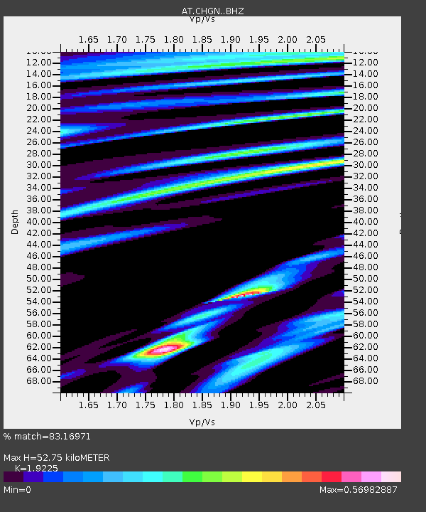
| Estimated Moho Depth: |
52.75 km |
| Estimated Crust Vp/Vs: |
1.92 |
| Assumed Crust Vp: |
6.134 km/s |
| Estimated Crust Vs: |
3.191 km/s |
| Estimated Crust Poisson's Ratio: |
0.31 |
|
| Radial Match: |
83.16971 % |
| Radial Bump: |
400 |
| Transverse Match: |
73.45208 % |
| Transverse Bump: |
400 |
| SOD ConfigId: |
7422571 |
| Insert Time: |
2019-04-21 04:15:05.031 +0000 |
| GWidth: |
2.5 |
| Max Bumps: |
400 |
| Tol: |
0.001 |
|

Signal To Noise
| Channel | StoN | STA | LTA |
| AT:CHGN: :BHZ:20151020T22:03:06.580029Z | 7.092548 | 4.866119E-6 | 6.86089E-7 |
| AT:CHGN: :BHN:20151020T22:03:06.580029Z | 2.435767 | 1.5664485E-6 | 6.4310285E-7 |
| AT:CHGN: :BHE:20151020T22:03:06.580029Z | 1.600352 | 8.9414885E-7 | 5.587201E-7 |
| Arrivals |
| Ps | 8.1 SECOND |
| PpPs | 24 SECOND |
| PsPs/PpSs | 33 SECOND |


