You are here: Home > Network List > AV - Alaska Volcano Observatory Stations List
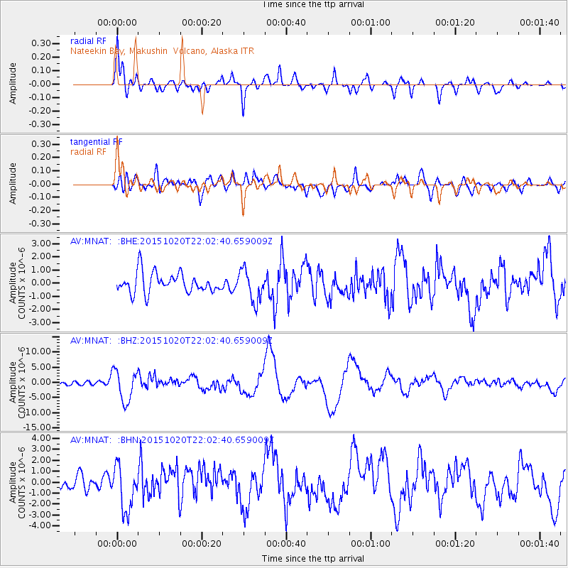
> Station MNAT Nateekin Bay, Makushin Volcano, Alaska > Earthquake Result Viewer
MNAT Nateekin Bay, Makushin Volcano, Alaska - Earthquake Result Viewer
| Earthquake location: |
Vanuatu Islands |
| Earthquake latitude/longitude: |
-14.8/167.3 |
| Earthquake time(UTC): |
2015/10/20 (293) 21:52:02 GMT |
| Earthquake Depth: |
127 km |
| Earthquake Magnitude: |
7.1 MWW, 7.3 MI |
| Earthquake Catalog/Contributor: |
NEIC PDE/NEIC COMCAT |
|
| Network: |
AV Alaska Volcano Observatory |
| Station: |
MNAT Nateekin Bay, Makushin Volcano, Alaska |
| Lat/Lon: |
53.88 N/166.69 W |
| Elevation: |
390 m |
|
| Distance: |
72.0 deg |
| Az: |
15.843 deg |
| Baz: |
206.483 deg |
| Ray Param: |
0.05364208 |
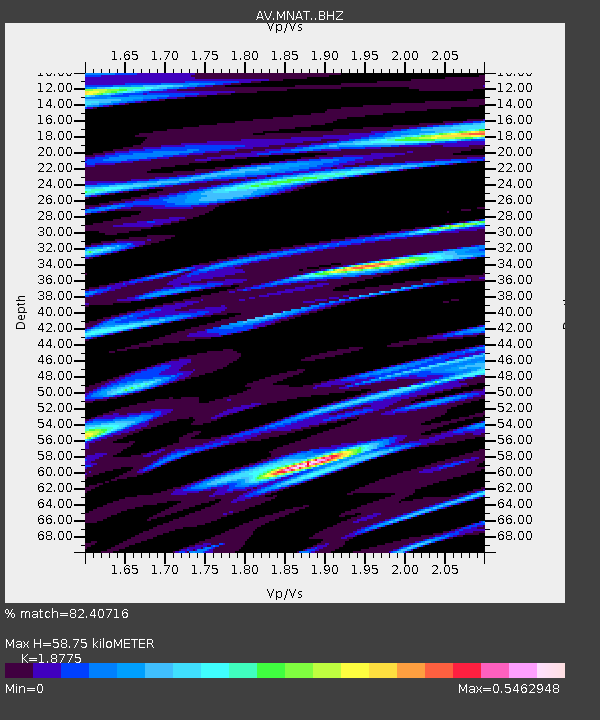
| Estimated Moho Depth: |
58.75 km |
| Estimated Crust Vp/Vs: |
1.88 |
| Assumed Crust Vp: |
3.943 km/s |
| Estimated Crust Vs: |
2.1 km/s |
| Estimated Crust Poisson's Ratio: |
0.30 |
|
| Radial Match: |
82.40716 % |
| Radial Bump: |
400 |
| Transverse Match: |
59.802055 % |
| Transverse Bump: |
400 |
| SOD ConfigId: |
7422571 |
| Insert Time: |
2019-04-21 04:15:39.027 +0000 |
| GWidth: |
2.5 |
| Max Bumps: |
400 |
| Tol: |
0.001 |
|
Signal To Noise
| Channel | StoN | STA | LTA |
| AV:MNAT: :BHZ:20151020T22:02:40.659009Z | 6.7140045 | 5.1705265E-6 | 7.7011066E-7 |
| AV:MNAT: :BHN:20151020T22:02:40.659009Z | 3.977776 | 2.1290045E-6 | 5.3522484E-7 |
| AV:MNAT: :BHE:20151020T22:02:40.659009Z | 1.6177541 | 1.2210293E-6 | 7.5476817E-7 |
| Arrivals |
| Ps | 13 SECOND |
| PpPs | 42 SECOND |
| PsPs/PpSs | 56 SECOND |


