You are here: Home > Network List > CC - Cascade Chain Volcano Monitoring Stations List
> Station CIHL Cinder Hill, Newberry, OR > Earthquake Result Viewer
CIHL Cinder Hill, Newberry, OR - Earthquake Result Viewer
| Earthquake location: |
Vanuatu Islands |
| Earthquake latitude/longitude: |
-14.8/167.3 |
| Earthquake time(UTC): |
2015/10/20 (293) 21:52:02 GMT |
| Earthquake Depth: |
127 km |
| Earthquake Magnitude: |
7.1 MWW, 7.3 MI |
| Earthquake Catalog/Contributor: |
NEIC PDE/NEIC COMCAT |
|
| Network: |
CC Cascade Chain Volcano Monitoring |
| Station: |
CIHL Cinder Hill, Newberry, OR |
| Lat/Lon: |
43.75 N/121.15 W |
| Elevation: |
1966 m |
|
| Distance: |
87.3 deg |
| Az: |
43.483 deg |
| Baz: |
246.682 deg |
| Ray Param: |
0.043122746 |
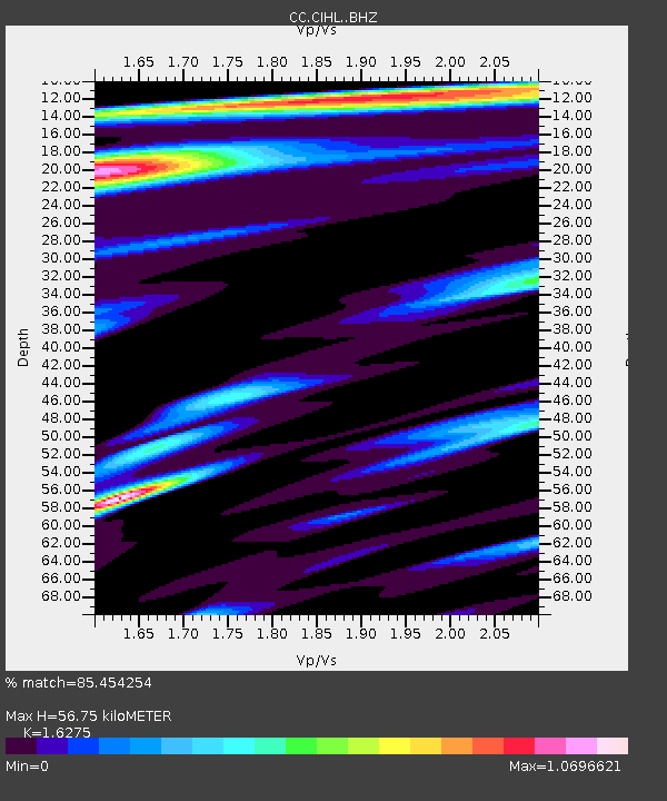
| Estimated Moho Depth: |
56.75 km |
| Estimated Crust Vp/Vs: |
1.63 |
| Assumed Crust Vp: |
6.597 km/s |
| Estimated Crust Vs: |
4.054 km/s |
| Estimated Crust Poisson's Ratio: |
0.20 |
|
| Radial Match: |
85.454254 % |
| Radial Bump: |
400 |
| Transverse Match: |
79.48607 % |
| Transverse Bump: |
400 |
| SOD ConfigId: |
7422571 |
| Insert Time: |
2019-04-21 04:16:36.040 +0000 |
| GWidth: |
2.5 |
| Max Bumps: |
400 |
| Tol: |
0.001 |
|

Signal To Noise
| Channel | StoN | STA | LTA |
| CC:CIHL: :BHZ:20151020T22:04:03.140027Z | 54.87635 | 7.64485E-6 | 1.3931046E-7 |
| CC:CIHL: :BHN:20151020T22:04:03.140027Z | 4.988403 | 9.1390274E-7 | 1.8320547E-7 |
| CC:CIHL: :BHE:20151020T22:04:03.140027Z | 6.025626 | 1.1323243E-6 | 1.8791812E-7 |
| Arrivals |
| Ps | 5.5 SECOND |
| PpPs | 22 SECOND |
| PsPs/PpSs | 28 SECOND |


