You are here: Home > Network List > CI - Caltech Regional Seismic Network Stations List
> Station CIA CIA, Avalon Catalina Island, CA, USA > Earthquake Result Viewer
CIA CIA, Avalon Catalina Island, CA, USA - Earthquake Result Viewer
| Earthquake location: |
Vanuatu Islands |
| Earthquake latitude/longitude: |
-14.8/167.3 |
| Earthquake time(UTC): |
2015/10/20 (293) 21:52:02 GMT |
| Earthquake Depth: |
127 km |
| Earthquake Magnitude: |
7.1 MWW, 7.3 MI |
| Earthquake Catalog/Contributor: |
NEIC PDE/NEIC COMCAT |
|
| Network: |
CI Caltech Regional Seismic Network |
| Station: |
CIA CIA, Avalon Catalina Island, CA, USA |
| Lat/Lon: |
33.40 N/118.41 W |
| Elevation: |
467 m |
|
| Distance: |
85.4 deg |
| Az: |
53.882 deg |
| Baz: |
249.045 deg |
| Ray Param: |
0.044490226 |
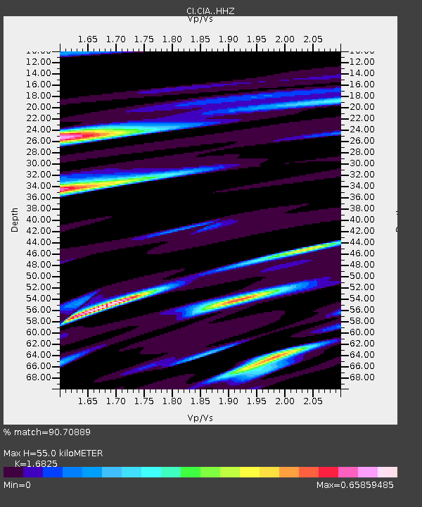
| Estimated Moho Depth: |
55.0 km |
| Estimated Crust Vp/Vs: |
1.68 |
| Assumed Crust Vp: |
6.048 km/s |
| Estimated Crust Vs: |
3.595 km/s |
| Estimated Crust Poisson's Ratio: |
0.23 |
|
| Radial Match: |
90.70889 % |
| Radial Bump: |
400 |
| Transverse Match: |
85.44748 % |
| Transverse Bump: |
400 |
| SOD ConfigId: |
7422571 |
| Insert Time: |
2019-04-21 04:16:57.141 +0000 |
| GWidth: |
2.5 |
| Max Bumps: |
400 |
| Tol: |
0.001 |
|

Signal To Noise
| Channel | StoN | STA | LTA |
| CI:CIA: :HHZ:20151020T22:03:53.847974Z | 29.722713 | 7.5860453E-6 | 2.552272E-7 |
| CI:CIA: :HHN:20151020T22:03:53.847974Z | 4.0617156 | 1.5320574E-6 | 3.7719465E-7 |
| CI:CIA: :HHE:20151020T22:03:53.847974Z | 7.6956863 | 2.7190054E-6 | 3.5331553E-7 |
| Arrivals |
| Ps | 6.3 SECOND |
| PpPs | 24 SECOND |
| PsPs/PpSs | 30 SECOND |


