You are here: Home > Network List > CI - Caltech Regional Seismic Network Stations List
> Station DGR Domenigoni Reservoir, California, USA > Earthquake Result Viewer
DGR Domenigoni Reservoir, California, USA - Earthquake Result Viewer
| Earthquake location: |
Vanuatu Islands |
| Earthquake latitude/longitude: |
-14.8/167.3 |
| Earthquake time(UTC): |
2015/10/20 (293) 21:52:02 GMT |
| Earthquake Depth: |
127 km |
| Earthquake Magnitude: |
7.1 MWW, 7.3 MI |
| Earthquake Catalog/Contributor: |
NEIC PDE/NEIC COMCAT |
|
| Network: |
CI Caltech Regional Seismic Network |
| Station: |
DGR Domenigoni Reservoir, California, USA |
| Lat/Lon: |
33.65 N/117.01 W |
| Elevation: |
609 m |
|
| Distance: |
86.6 deg |
| Az: |
54.063 deg |
| Baz: |
249.83 deg |
| Ray Param: |
0.043643452 |
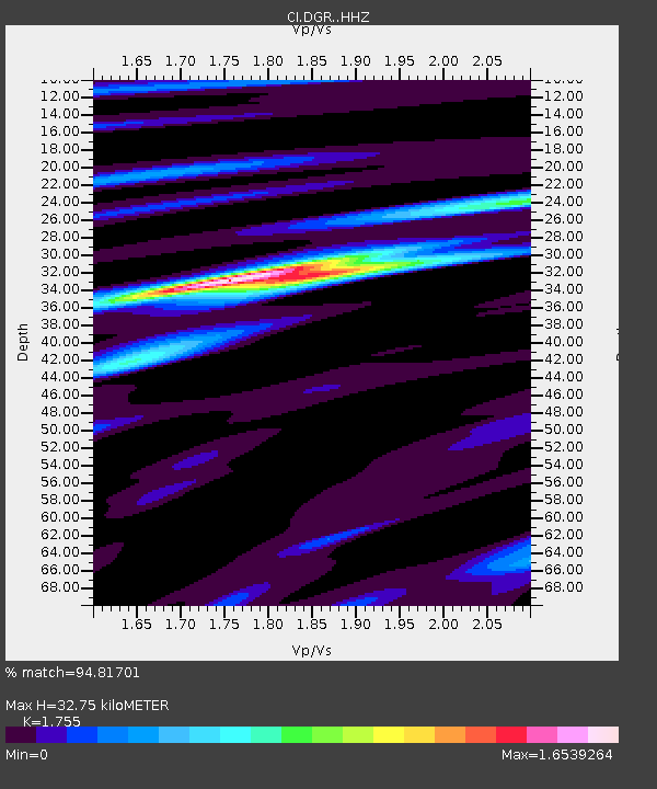
| Estimated Moho Depth: |
32.75 km |
| Estimated Crust Vp/Vs: |
1.75 |
| Assumed Crust Vp: |
6.264 km/s |
| Estimated Crust Vs: |
3.569 km/s |
| Estimated Crust Poisson's Ratio: |
0.26 |
|
| Radial Match: |
94.81701 % |
| Radial Bump: |
361 |
| Transverse Match: |
87.655975 % |
| Transverse Bump: |
400 |
| SOD ConfigId: |
7422571 |
| Insert Time: |
2019-04-21 04:17:00.630 +0000 |
| GWidth: |
2.5 |
| Max Bumps: |
400 |
| Tol: |
0.001 |
|
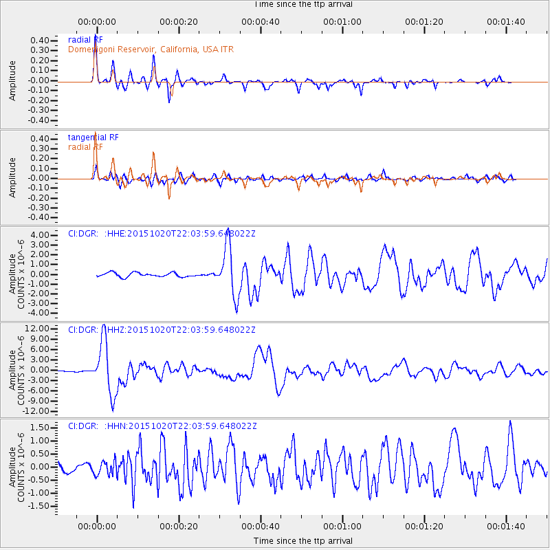
Signal To Noise
| Channel | StoN | STA | LTA |
| CI:DGR: :HHZ:20151020T22:03:59.648022Z | 38.707817 | 7.991386E-6 | 2.0645408E-7 |
| CI:DGR: :HHN:20151020T22:03:59.648022Z | 2.0160086 | 2.6091087E-7 | 1.2941952E-7 |
| CI:DGR: :HHE:20151020T22:03:59.648022Z | 12.469584 | 2.6556022E-6 | 2.1296637E-7 |
| Arrivals |
| Ps | 4.0 SECOND |
| PpPs | 14 SECOND |
| PsPs/PpSs | 18 SECOND |


