You are here: Home > Network List > CI - Caltech Regional Seismic Network Stations List
> Station IKP In-Ko-Pah, Jacumba, CA, USA > Earthquake Result Viewer
IKP In-Ko-Pah, Jacumba, CA, USA - Earthquake Result Viewer
| Earthquake location: |
Vanuatu Islands |
| Earthquake latitude/longitude: |
-14.8/167.3 |
| Earthquake time(UTC): |
2015/10/20 (293) 21:52:02 GMT |
| Earthquake Depth: |
127 km |
| Earthquake Magnitude: |
7.1 MWW, 7.3 MI |
| Earthquake Catalog/Contributor: |
NEIC PDE/NEIC COMCAT |
|
| Network: |
CI Caltech Regional Seismic Network |
| Station: |
IKP In-Ko-Pah, Jacumba, CA, USA |
| Lat/Lon: |
32.65 N/116.11 W |
| Elevation: |
906 m |
|
| Distance: |
87.0 deg |
| Az: |
55.259 deg |
| Baz: |
250.386 deg |
| Ray Param: |
0.043375894 |
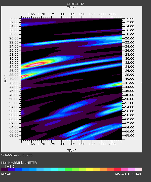
| Estimated Moho Depth: |
38.5 km |
| Estimated Crust Vp/Vs: |
1.60 |
| Assumed Crust Vp: |
6.264 km/s |
| Estimated Crust Vs: |
3.915 km/s |
| Estimated Crust Poisson's Ratio: |
0.18 |
|
| Radial Match: |
91.63255 % |
| Radial Bump: |
400 |
| Transverse Match: |
79.39928 % |
| Transverse Bump: |
400 |
| SOD ConfigId: |
7422571 |
| Insert Time: |
2019-04-21 04:17:12.529 +0000 |
| GWidth: |
2.5 |
| Max Bumps: |
400 |
| Tol: |
0.001 |
|

Signal To Noise
| Channel | StoN | STA | LTA |
| CI:IKP: :HHZ:20151020T22:04:01.427991Z | 28.129478 | 7.6229503E-6 | 2.709951E-7 |
| CI:IKP: :HHN:20151020T22:04:01.427991Z | 1.6861075 | 3.0921404E-7 | 1.8338929E-7 |
| CI:IKP: :HHE:20151020T22:04:01.427991Z | 9.795886 | 2.5790557E-6 | 2.6327947E-7 |
| Arrivals |
| Ps | 3.8 SECOND |
| PpPs | 16 SECOND |
| PsPs/PpSs | 19 SECOND |


