You are here: Home > Network List > PB - Plate Boundary Observatory Borehole Seismic Network Stations List
> Station B088A skyoks088bcs2007, Anza, CA, USA > Earthquake Result Viewer
B088A skyoks088bcs2007, Anza, CA, USA - Earthquake Result Viewer
| Earthquake location: |
Vanuatu Islands |
| Earthquake latitude/longitude: |
-14.8/167.3 |
| Earthquake time(UTC): |
2015/10/20 (293) 21:52:02 GMT |
| Earthquake Depth: |
127 km |
| Earthquake Magnitude: |
7.1 MWW, 7.3 MI |
| Earthquake Catalog/Contributor: |
NEIC PDE/NEIC COMCAT |
|
| Network: |
PB Plate Boundary Observatory Borehole Seismic Network |
| Station: |
B088A skyoks088bcs2007, Anza, CA, USA |
| Lat/Lon: |
33.37 N/116.62 W |
| Elevation: |
1404 m |
|
| Distance: |
86.8 deg |
| Az: |
54.433 deg |
| Baz: |
250.064 deg |
| Ray Param: |
0.04348977 |
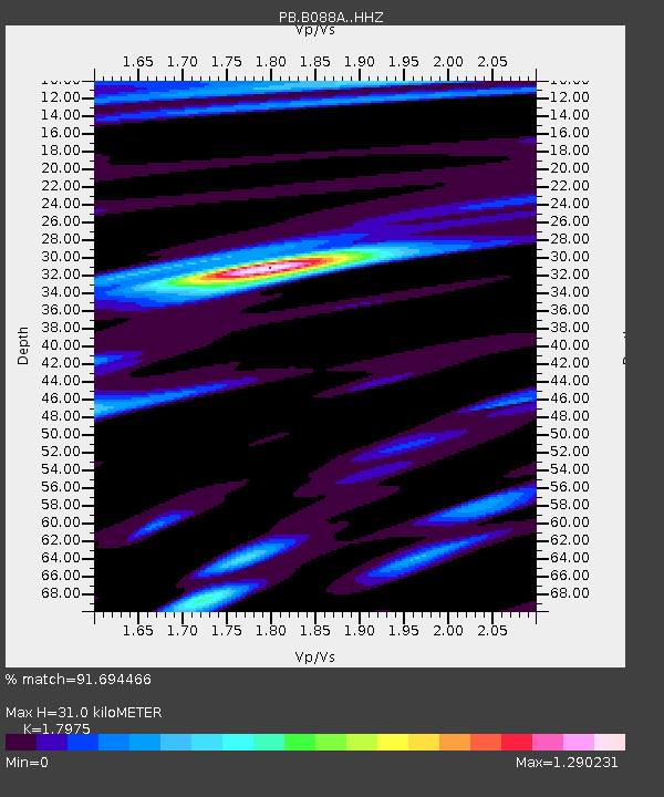
| Estimated Moho Depth: |
31.0 km |
| Estimated Crust Vp/Vs: |
1.80 |
| Assumed Crust Vp: |
6.264 km/s |
| Estimated Crust Vs: |
3.485 km/s |
| Estimated Crust Poisson's Ratio: |
0.28 |
|
| Radial Match: |
91.694466 % |
| Radial Bump: |
400 |
| Transverse Match: |
83.99423 % |
| Transverse Bump: |
400 |
| SOD ConfigId: |
7422571 |
| Insert Time: |
2019-04-21 04:20:06.944 +0000 |
| GWidth: |
2.5 |
| Max Bumps: |
400 |
| Tol: |
0.001 |
|

Signal To Noise
| Channel | StoN | STA | LTA |
| PB:B088A: :HHZ:20151020T22:04:00.659009Z | 33.656998 | 8.799422E-6 | 2.6144406E-7 |
| PB:B088A: :HHN:20151020T22:04:00.659009Z | 7.3399134 | 1.609473E-6 | 2.1927684E-7 |
| PB:B088A: :HHE:20151020T22:04:00.659009Z | 8.595801 | 2.4356168E-6 | 2.8334958E-7 |
| Arrivals |
| Ps | 4.0 SECOND |
| PpPs | 14 SECOND |
| PsPs/PpSs | 18 SECOND |


