You are here: Home > Network List > RV - Regional Alberta Seismic Observatory for Earthquake Studies Network Stations List
> Station BRLDA Berland Lookout Tower, AB > Earthquake Result Viewer
BRLDA Berland Lookout Tower, AB - Earthquake Result Viewer
| Earthquake location: |
Vanuatu Islands |
| Earthquake latitude/longitude: |
-14.8/167.3 |
| Earthquake time(UTC): |
2015/10/20 (293) 21:52:02 GMT |
| Earthquake Depth: |
127 km |
| Earthquake Magnitude: |
7.1 MWW, 7.3 MI |
| Earthquake Catalog/Contributor: |
NEIC PDE/NEIC COMCAT |
|
| Network: |
RV Regional Alberta Seismic Observatory for Earthquake Studies Network |
| Station: |
BRLDA Berland Lookout Tower, AB |
| Lat/Lon: |
54.09 N/117.40 W |
| Elevation: |
1224 m |
|
| Distance: |
93.5 deg |
| Az: |
34.808 deg |
| Baz: |
249.572 deg |
| Ray Param: |
0.041177005 |
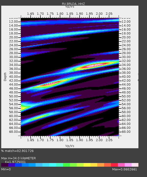
| Estimated Moho Depth: |
34.0 km |
| Estimated Crust Vp/Vs: |
1.97 |
| Assumed Crust Vp: |
6.426 km/s |
| Estimated Crust Vs: |
3.258 km/s |
| Estimated Crust Poisson's Ratio: |
0.33 |
|
| Radial Match: |
82.901726 % |
| Radial Bump: |
400 |
| Transverse Match: |
69.11252 % |
| Transverse Bump: |
400 |
| SOD ConfigId: |
7422571 |
| Insert Time: |
2019-04-21 04:20:22.607 +0000 |
| GWidth: |
2.5 |
| Max Bumps: |
400 |
| Tol: |
0.001 |
|

Signal To Noise
| Channel | StoN | STA | LTA |
| RV:BRLDA: :HHZ:20151020T22:04:31.729993Z | 16.67843 | 4.425052E-6 | 2.6531583E-7 |
| RV:BRLDA: :HHN:20151020T22:04:31.729993Z | 2.880827 | 7.073169E-7 | 2.4552563E-7 |
| RV:BRLDA: :HHE:20151020T22:04:31.729993Z | 3.5328999 | 1.2081873E-6 | 3.4198177E-7 |
| Arrivals |
| Ps | 5.2 SECOND |
| PpPs | 15 SECOND |
| PsPs/PpSs | 21 SECOND |


