You are here: Home > Network List > TA - USArray Transportable Network (new EarthScope stations) Stations List
> Station G05D Wamic, OR, USA > Earthquake Result Viewer
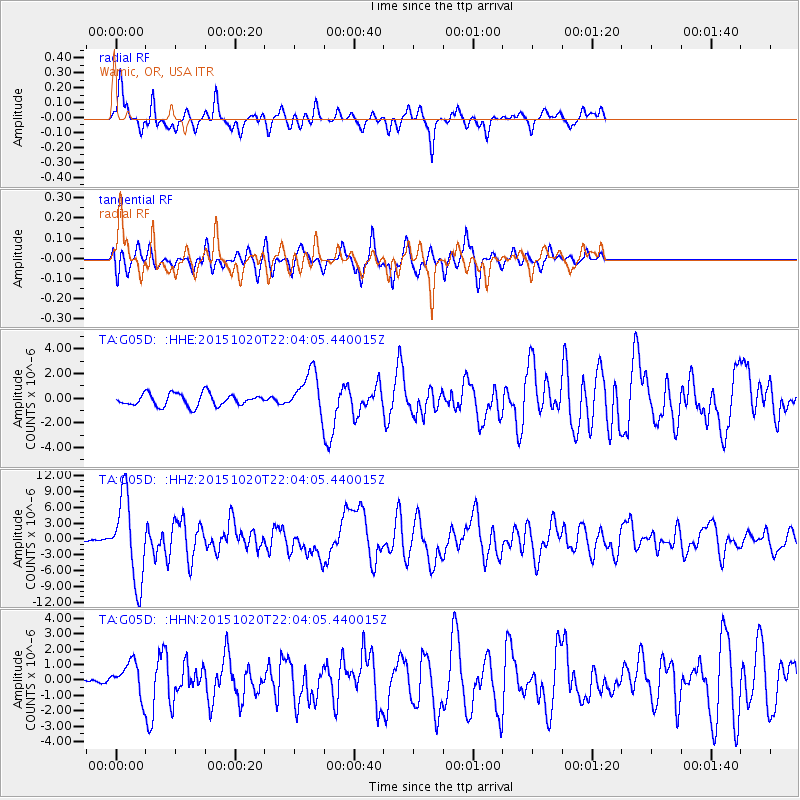
G05D Wamic, OR, USA - Earthquake Result Viewer
*The percent match for this event was below the threshold and hence no stack was calculated.
| Earthquake location: |
Vanuatu Islands |
| Earthquake latitude/longitude: |
-14.8/167.3 |
| Earthquake time(UTC): |
2015/10/20 (293) 21:52:02 GMT |
| Earthquake Depth: |
127 km |
| Earthquake Magnitude: |
7.1 MWW, 7.3 MI |
| Earthquake Catalog/Contributor: |
NEIC PDE/NEIC COMCAT |
|
| Network: |
TA USArray Transportable Network (new EarthScope stations) |
| Station: |
G05D Wamic, OR, USA |
| Lat/Lon: |
45.24 N/121.32 W |
| Elevation: |
592 m |
|
| Distance: |
87.8 deg |
| Az: |
42.066 deg |
| Baz: |
246.504 deg |
| Ray Param: |
$rayparam |
*The percent match for this event was below the threshold and hence was not used in the summary stack. |
|
| Radial Match: |
72.63955 % |
| Radial Bump: |
347 |
| Transverse Match: |
73.584335 % |
| Transverse Bump: |
400 |
| SOD ConfigId: |
7422571 |
| Insert Time: |
2019-04-21 04:20:55.010 +0000 |
| GWidth: |
2.5 |
| Max Bumps: |
400 |
| Tol: |
0.001 |
|
Signal To Noise
| Channel | StoN | STA | LTA |
| TA:G05D: :HHZ:20151020T22:04:05.440015Z | 28.098253 | 7.869965E-6 | 2.8008736E-7 |
| TA:G05D: :HHN:20151020T22:04:05.440015Z | 1.7373428 | 1.1355713E-6 | 6.5362536E-7 |
| TA:G05D: :HHE:20151020T22:04:05.440015Z | 3.881889 | 1.9307022E-6 | 4.973615E-7 |
| Arrivals |
| Ps | |
| PpPs | |
| PsPs/PpSs | |


