You are here: Home > Network List > TA - USArray Transportable Network (new EarthScope stations) Stations List
> Station I23K Minto, Yukon-Koyukuk, AK, USA > Earthquake Result Viewer
I23K Minto, Yukon-Koyukuk, AK, USA - Earthquake Result Viewer
| Earthquake location: |
Vanuatu Islands |
| Earthquake latitude/longitude: |
-14.8/167.3 |
| Earthquake time(UTC): |
2015/10/20 (293) 21:52:02 GMT |
| Earthquake Depth: |
127 km |
| Earthquake Magnitude: |
7.1 MWW, 7.3 MI |
| Earthquake Catalog/Contributor: |
NEIC PDE/NEIC COMCAT |
|
| Network: |
TA USArray Transportable Network (new EarthScope stations) |
| Station: |
I23K Minto, Yukon-Koyukuk, AK, USA |
| Lat/Lon: |
65.15 N/149.36 W |
| Elevation: |
149 m |
|
| Distance: |
86.2 deg |
| Az: |
16.897 deg |
| Baz: |
221.691 deg |
| Ray Param: |
0.04395671 |
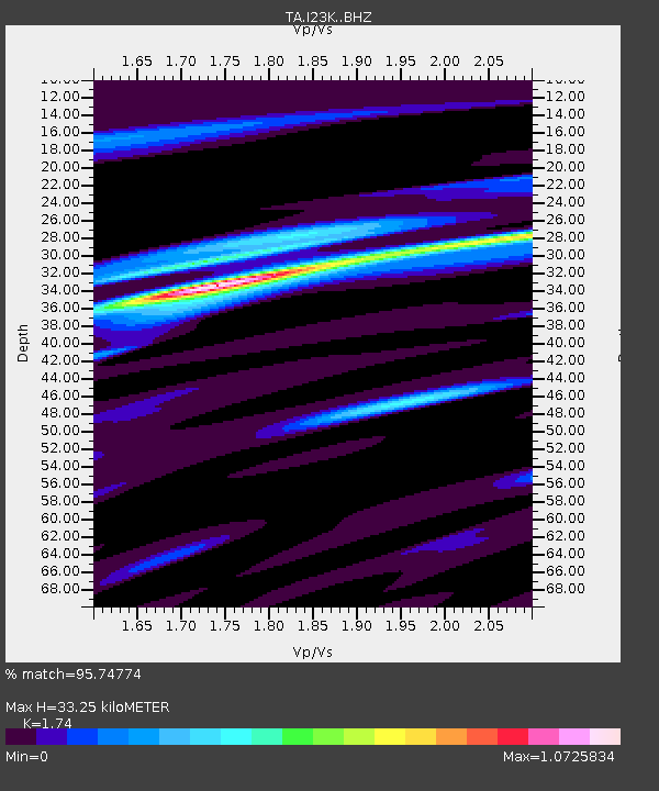
| Estimated Moho Depth: |
33.25 km |
| Estimated Crust Vp/Vs: |
1.74 |
| Assumed Crust Vp: |
6.566 km/s |
| Estimated Crust Vs: |
3.774 km/s |
| Estimated Crust Poisson's Ratio: |
0.25 |
|
| Radial Match: |
95.74774 % |
| Radial Bump: |
345 |
| Transverse Match: |
82.38187 % |
| Transverse Bump: |
400 |
| SOD ConfigId: |
7422571 |
| Insert Time: |
2019-04-21 04:21:04.923 +0000 |
| GWidth: |
2.5 |
| Max Bumps: |
400 |
| Tol: |
0.001 |
|
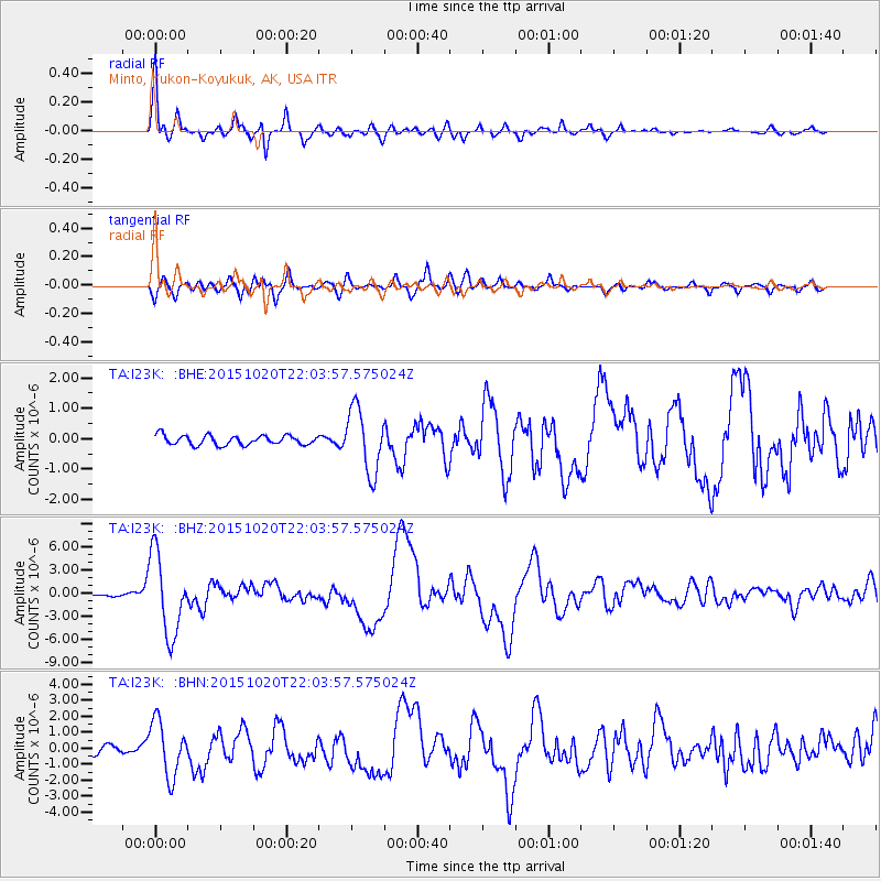
Signal To Noise
| Channel | StoN | STA | LTA |
| TA:I23K: :BHZ:20151020T22:03:57.575024Z | 35.05189 | 5.264018E-6 | 1.5017787E-7 |
| TA:I23K: :BHN:20151020T22:03:57.575024Z | 4.4284945 | 1.7095238E-6 | 3.8602823E-7 |
| TA:I23K: :BHE:20151020T22:03:57.575024Z | 6.704507 | 1.0563027E-6 | 1.5755114E-7 |
| Arrivals |
| Ps | 3.8 SECOND |
| PpPs | 14 SECOND |
| PsPs/PpSs | 17 SECOND |


