You are here: Home > Network List > TA - USArray Transportable Network (new EarthScope stations) Stations List
> Station L26K Log Cabin Wilderness Lodge, Tok, AK, USA > Earthquake Result Viewer
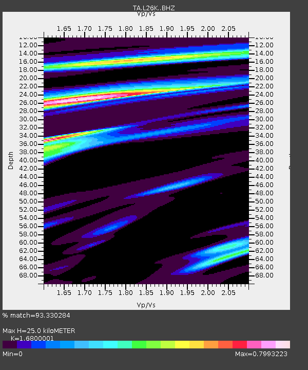
L26K Log Cabin Wilderness Lodge, Tok, AK, USA - Earthquake Result Viewer
| Earthquake location: |
Vanuatu Islands |
| Earthquake latitude/longitude: |
-14.8/167.3 |
| Earthquake time(UTC): |
2015/10/20 (293) 21:52:02 GMT |
| Earthquake Depth: |
127 km |
| Earthquake Magnitude: |
7.1 MWW, 7.3 MI |
| Earthquake Catalog/Contributor: |
NEIC PDE/NEIC COMCAT |
|
| Network: |
TA USArray Transportable Network (new EarthScope stations) |
| Station: |
L26K Log Cabin Wilderness Lodge, Tok, AK, USA |
| Lat/Lon: |
63.03 N/143.35 W |
| Elevation: |
650 m |
|
| Distance: |
86.5 deg |
| Az: |
20.28 deg |
| Baz: |
227.31 deg |
| Ray Param: |
0.043714393 |
| Estimated Moho Depth: |
25.0 km |
| Estimated Crust Vp/Vs: |
1.68 |
| Assumed Crust Vp: |
6.566 km/s |
| Estimated Crust Vs: |
3.908 km/s |
| Estimated Crust Poisson's Ratio: |
0.23 |
|
| Radial Match: |
93.330284 % |
| Radial Bump: |
400 |
| Transverse Match: |
64.192085 % |
| Transverse Bump: |
400 |
| SOD ConfigId: |
7422571 |
| Insert Time: |
2019-04-21 04:21:17.214 +0000 |
| GWidth: |
2.5 |
| Max Bumps: |
400 |
| Tol: |
0.001 |
|

Signal To Noise
| Channel | StoN | STA | LTA |
| TA:L26K: :BHZ:20151020T22:03:59.200024Z | 15.001689 | 4.2283473E-6 | 2.818581E-7 |
| TA:L26K: :BHN:20151020T22:03:59.200024Z | 2.7896657 | 4.7425706E-7 | 1.7000498E-7 |
| TA:L26K: :BHE:20151020T22:03:59.200024Z | 6.3561697 | 8.637499E-7 | 1.3589158E-7 |
| Arrivals |
| Ps | 2.7 SECOND |
| PpPs | 9.9 SECOND |
| PsPs/PpSs | 13 SECOND |


