You are here: Home > Network List > XD14 - Illuminating the architecture of the greater Mount St. Helens magmatic systems f Stations List
> Station MH09 "Mount St Helens, WA" > Earthquake Result Viewer
MH09 "Mount St Helens, WA" - Earthquake Result Viewer
| Earthquake location: |
Vanuatu Islands |
| Earthquake latitude/longitude: |
-14.8/167.3 |
| Earthquake time(UTC): |
2015/10/20 (293) 21:52:02 GMT |
| Earthquake Depth: |
127 km |
| Earthquake Magnitude: |
7.1 MWW, 7.3 MI |
| Earthquake Catalog/Contributor: |
NEIC PDE/NEIC COMCAT |
|
| Network: |
XD Illuminating the architecture of the greater Mount St. Helens magmatic systems f |
| Station: |
MH09 "Mount St Helens, WA" |
| Lat/Lon: |
46.30 N/121.80 W |
| Elevation: |
989 m |
|
| Distance: |
87.9 deg |
| Az: |
40.962 deg |
| Baz: |
246.118 deg |
| Ray Param: |
0.042683203 |
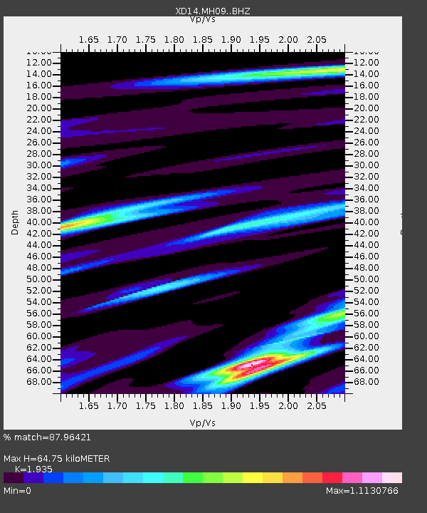
| Estimated Moho Depth: |
64.75 km |
| Estimated Crust Vp/Vs: |
1.93 |
| Assumed Crust Vp: |
6.597 km/s |
| Estimated Crust Vs: |
3.41 km/s |
| Estimated Crust Poisson's Ratio: |
0.32 |
|
| Radial Match: |
87.96421 % |
| Radial Bump: |
400 |
| Transverse Match: |
87.639244 % |
| Transverse Bump: |
400 |
| SOD ConfigId: |
7422571 |
| Insert Time: |
2019-04-21 04:23:05.377 +0000 |
| GWidth: |
2.5 |
| Max Bumps: |
400 |
| Tol: |
0.001 |
|

Signal To Noise
| Channel | StoN | STA | LTA |
| XD:MH09: :BHZ:20151020T22:04:05.984998Z | 49.394375 | 5.362654E-6 | 1.0856811E-7 |
| XD:MH09: :BHN:20151020T22:04:05.984998Z | 5.6707883 | 8.5162156E-7 | 1.5017693E-7 |
| XD:MH09: :BHE:20151020T22:04:05.984998Z | 7.541096 | 1.3541692E-6 | 1.7957193E-7 |
| Arrivals |
| Ps | 9.4 SECOND |
| PpPs | 28 SECOND |
| PsPs/PpSs | 38 SECOND |


