You are here: Home > Network List > XD14 - Illuminating the architecture of the greater Mount St. Helens magmatic systems f Stations List
> Station MJ01 "Mount St Helens, WA" > Earthquake Result Viewer
MJ01 "Mount St Helens, WA" - Earthquake Result Viewer
| Earthquake location: |
Vanuatu Islands |
| Earthquake latitude/longitude: |
-14.8/167.3 |
| Earthquake time(UTC): |
2015/10/20 (293) 21:52:02 GMT |
| Earthquake Depth: |
127 km |
| Earthquake Magnitude: |
7.1 MWW, 7.3 MI |
| Earthquake Catalog/Contributor: |
NEIC PDE/NEIC COMCAT |
|
| Network: |
XD Illuminating the architecture of the greater Mount St. Helens magmatic systems f |
| Station: |
MJ01 "Mount St Helens, WA" |
| Lat/Lon: |
46.19 N/122.81 W |
| Elevation: |
339 m |
|
| Distance: |
87.3 deg |
| Az: |
40.769 deg |
| Baz: |
245.382 deg |
| Ray Param: |
0.043186408 |
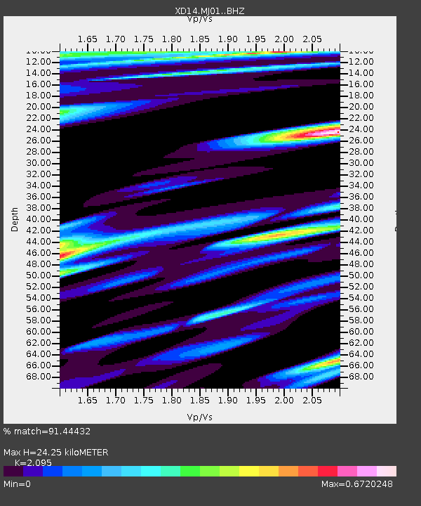
| Estimated Moho Depth: |
24.25 km |
| Estimated Crust Vp/Vs: |
2.10 |
| Assumed Crust Vp: |
6.566 km/s |
| Estimated Crust Vs: |
3.134 km/s |
| Estimated Crust Poisson's Ratio: |
0.35 |
|
| Radial Match: |
91.44432 % |
| Radial Bump: |
314 |
| Transverse Match: |
83.483955 % |
| Transverse Bump: |
400 |
| SOD ConfigId: |
7422571 |
| Insert Time: |
2019-04-21 04:23:09.799 +0000 |
| GWidth: |
2.5 |
| Max Bumps: |
400 |
| Tol: |
0.001 |
|

Signal To Noise
| Channel | StoN | STA | LTA |
| XD:MJ01: :BHZ:20151020T22:04:02.729993Z | 41.456253 | 9.131409E-6 | 2.2026613E-7 |
| XD:MJ01: :BHN:20151020T22:04:02.729993Z | 3.3176026 | 1.0024849E-6 | 3.0217146E-7 |
| XD:MJ01: :BHE:20151020T22:04:02.729993Z | 8.902346 | 3.1508273E-6 | 3.5393222E-7 |
| Arrivals |
| Ps | 4.1 SECOND |
| PpPs | 11 SECOND |
| PsPs/PpSs | 15 SECOND |


