You are here: Home > Network List > XD14 - Illuminating the architecture of the greater Mount St. Helens magmatic systems f Stations List
> Station ML03 "Mount St Helens, WA" > Earthquake Result Viewer
ML03 "Mount St Helens, WA" - Earthquake Result Viewer
| Earthquake location: |
Vanuatu Islands |
| Earthquake latitude/longitude: |
-14.8/167.3 |
| Earthquake time(UTC): |
2015/10/20 (293) 21:52:02 GMT |
| Earthquake Depth: |
127 km |
| Earthquake Magnitude: |
7.1 MWW, 7.3 MI |
| Earthquake Catalog/Contributor: |
NEIC PDE/NEIC COMCAT |
|
| Network: |
XD Illuminating the architecture of the greater Mount St. Helens magmatic systems f |
| Station: |
ML03 "Mount St Helens, WA" |
| Lat/Lon: |
46.06 N/122.52 W |
| Elevation: |
356 m |
|
| Distance: |
87.4 deg |
| Az: |
40.974 deg |
| Baz: |
245.604 deg |
| Ray Param: |
0.043088738 |
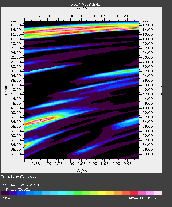
| Estimated Moho Depth: |
53.25 km |
| Estimated Crust Vp/Vs: |
1.67 |
| Assumed Crust Vp: |
6.566 km/s |
| Estimated Crust Vs: |
3.932 km/s |
| Estimated Crust Poisson's Ratio: |
0.22 |
|
| Radial Match: |
85.47091 % |
| Radial Bump: |
400 |
| Transverse Match: |
85.694954 % |
| Transverse Bump: |
400 |
| SOD ConfigId: |
7422571 |
| Insert Time: |
2019-04-21 04:23:19.919 +0000 |
| GWidth: |
2.5 |
| Max Bumps: |
400 |
| Tol: |
0.001 |
|

Signal To Noise
| Channel | StoN | STA | LTA |
| XD:ML03: :BHZ:20151020T22:04:03.365002Z | 52.29997 | 6.7389446E-6 | 1.2885178E-7 |
| XD:ML03: :BHN:20151020T22:04:03.365002Z | 8.879069 | 1.6632329E-6 | 1.8732064E-7 |
| XD:ML03: :BHE:20151020T22:04:03.365002Z | 2.798598 | 6.9613014E-7 | 2.4874245E-7 |
| Arrivals |
| Ps | 5.6 SECOND |
| PpPs | 21 SECOND |
| PsPs/PpSs | 27 SECOND |


