You are here: Home > Network List > XD14 - Illuminating the architecture of the greater Mount St. Helens magmatic systems f Stations List
> Station MN07 "Mount St Helens, WA" > Earthquake Result Viewer
MN07 "Mount St Helens, WA" - Earthquake Result Viewer
| Earthquake location: |
Vanuatu Islands |
| Earthquake latitude/longitude: |
-14.8/167.3 |
| Earthquake time(UTC): |
2015/10/20 (293) 21:52:02 GMT |
| Earthquake Depth: |
127 km |
| Earthquake Magnitude: |
7.1 MWW, 7.3 MI |
| Earthquake Catalog/Contributor: |
NEIC PDE/NEIC COMCAT |
|
| Network: |
XD Illuminating the architecture of the greater Mount St. Helens magmatic systems f |
| Station: |
MN07 "Mount St Helens, WA" |
| Lat/Lon: |
45.99 N/122.08 W |
| Elevation: |
861 m |
|
| Distance: |
87.6 deg |
| Az: |
41.162 deg |
| Baz: |
245.924 deg |
| Ray Param: |
0.04290626 |
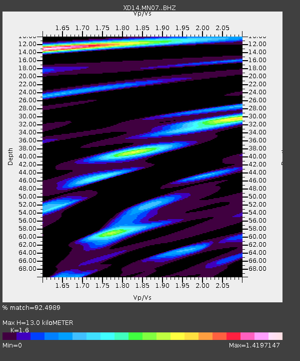
| Estimated Moho Depth: |
13.0 km |
| Estimated Crust Vp/Vs: |
1.60 |
| Assumed Crust Vp: |
6.566 km/s |
| Estimated Crust Vs: |
4.104 km/s |
| Estimated Crust Poisson's Ratio: |
0.18 |
|
| Radial Match: |
92.4989 % |
| Radial Bump: |
400 |
| Transverse Match: |
81.93052 % |
| Transverse Bump: |
400 |
| SOD ConfigId: |
7422571 |
| Insert Time: |
2019-04-21 04:23:25.846 +0000 |
| GWidth: |
2.5 |
| Max Bumps: |
400 |
| Tol: |
0.001 |
|

Signal To Noise
| Channel | StoN | STA | LTA |
| XD:MN07: :BHZ:20151020T22:04:04.544995Z | 46.968483 | 6.7110814E-6 | 1.4288479E-7 |
| XD:MN07: :BHN:20151020T22:04:04.544995Z | 6.5658336 | 1.2566555E-6 | 1.9139316E-7 |
| XD:MN07: :BHE:20151020T22:04:04.544995Z | 10.882125 | 2.1288229E-6 | 1.9562565E-7 |
| Arrivals |
| Ps | 1.2 SECOND |
| PpPs | 5.0 SECOND |
| PsPs/PpSs | 6.2 SECOND |


