You are here: Home > Network List > XD14 - Illuminating the architecture of the greater Mount St. Helens magmatic systems f Stations List
> Station MP10 "Mount St Helens, WA" > Earthquake Result Viewer
MP10 "Mount St Helens, WA" - Earthquake Result Viewer
| Earthquake location: |
Vanuatu Islands |
| Earthquake latitude/longitude: |
-14.8/167.3 |
| Earthquake time(UTC): |
2015/10/20 (293) 21:52:02 GMT |
| Earthquake Depth: |
127 km |
| Earthquake Magnitude: |
7.1 MWW, 7.3 MI |
| Earthquake Catalog/Contributor: |
NEIC PDE/NEIC COMCAT |
|
| Network: |
XD Illuminating the architecture of the greater Mount St. Helens magmatic systems f |
| Station: |
MP10 "Mount St Helens, WA" |
| Lat/Lon: |
45.90 N/121.80 W |
| Elevation: |
1130 m |
|
| Distance: |
87.8 deg |
| Az: |
41.328 deg |
| Baz: |
246.131 deg |
| Ray Param: |
0.042802285 |
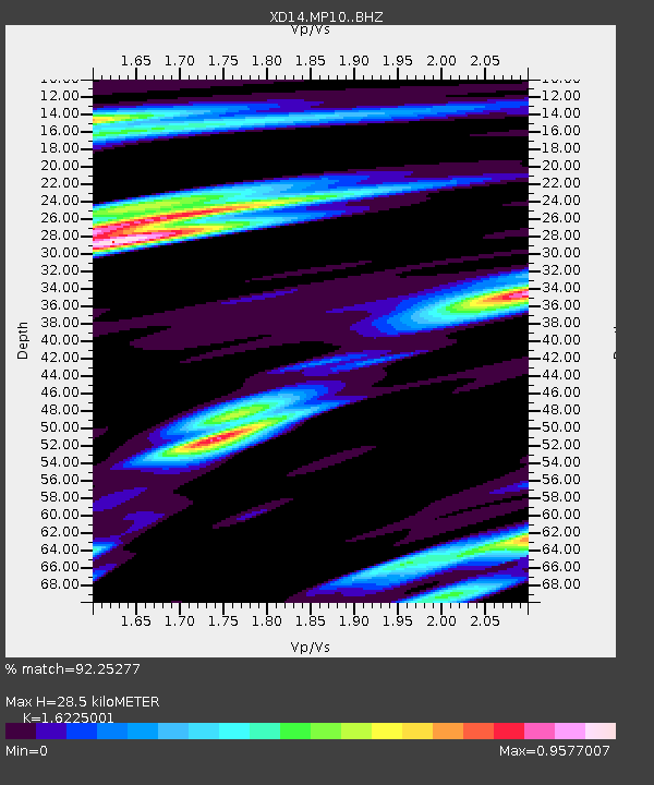
| Estimated Moho Depth: |
28.5 km |
| Estimated Crust Vp/Vs: |
1.62 |
| Assumed Crust Vp: |
6.597 km/s |
| Estimated Crust Vs: |
4.066 km/s |
| Estimated Crust Poisson's Ratio: |
0.19 |
|
| Radial Match: |
92.25277 % |
| Radial Bump: |
400 |
| Transverse Match: |
84.13817 % |
| Transverse Bump: |
400 |
| SOD ConfigId: |
7422571 |
| Insert Time: |
2019-04-21 04:23:32.480 +0000 |
| GWidth: |
2.5 |
| Max Bumps: |
400 |
| Tol: |
0.001 |
|

Signal To Noise
| Channel | StoN | STA | LTA |
| XD:MP10: :BHZ:20151020T22:04:05.214978Z | 40.1554 | 7.3601313E-6 | 1.8329119E-7 |
| XD:MP10: :BHN:20151020T22:04:05.214978Z | 6.0941963 | 6.325858E-7 | 1.0380134E-7 |
| XD:MP10: :BHE:20151020T22:04:05.214978Z | 13.893535 | 2.376954E-6 | 1.7108347E-7 |
| Arrivals |
| Ps | 2.8 SECOND |
| PpPs | 11 SECOND |
| PsPs/PpSs | 14 SECOND |


