You are here: Home > Network List > UU - University of Utah Regional Network Stations List
> Station KNB Kanab, UT, USA > Earthquake Result Viewer
KNB Kanab, UT, USA - Earthquake Result Viewer
| Earthquake location: |
Alaska Peninsula |
| Earthquake latitude/longitude: |
56.7/-156.5 |
| Earthquake time(UTC): |
2015/05/29 (149) 07:00:08 GMT |
| Earthquake Depth: |
62 km |
| Earthquake Magnitude: |
6.8 MWP, 6.8 MI |
| Earthquake Catalog/Contributor: |
NEIC PDE/NEIC COMCAT |
|
| Network: |
UU University of Utah Regional Network |
| Station: |
KNB Kanab, UT, USA |
| Lat/Lon: |
37.02 N/112.82 W |
| Elevation: |
1715 m |
|
| Distance: |
35.0 deg |
| Az: |
105.353 deg |
| Baz: |
318.343 deg |
| Ray Param: |
0.07728791 |
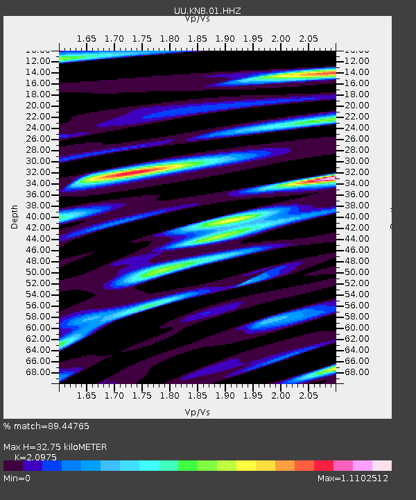
| Estimated Moho Depth: |
32.75 km |
| Estimated Crust Vp/Vs: |
2.10 |
| Assumed Crust Vp: |
6.194 km/s |
| Estimated Crust Vs: |
2.953 km/s |
| Estimated Crust Poisson's Ratio: |
0.35 |
|
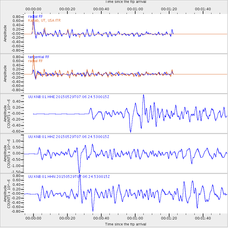
| Radial Match: |
89.44765 % |
| Radial Bump: |
400 |
| Transverse Match: |
66.191795 % |
| Transverse Bump: |
400 |
| SOD ConfigId: |
976571 |
| Insert Time: |
2015-06-12 07:23:00.131 +0000 |
| GWidth: |
2.5 |
| Max Bumps: |
400 |
| Tol: |
0.001 |
|
Signal To Noise
| Channel | StoN | STA | LTA |
| UU:KNB:01:HHZ:20150529T07:06:24.530015Z | 34.563595 | 1.944439E-7 | 5.625685E-9 |
| UU:KNB:01:HHN:20150529T07:06:24.530015Z | 18.10974 | 1.15280265E-7 | 6.36565E-9 |
| UU:KNB:01:HHE:20150529T07:06:24.530015Z | 16.704037 | 7.7522735E-8 | 4.640958E-9 |
| Arrivals |
| Ps | 6.2 SECOND |
| PpPs | 15 SECOND |
| PsPs/PpSs | 22 SECOND |


