You are here: Home > Network List > XV14 - Fault Locations and Alaska Tectonics from Seismicity Stations List
> Station FAPT Nenana Airport, AK, USA > Earthquake Result Viewer
FAPT Nenana Airport, AK, USA - Earthquake Result Viewer
| Earthquake location: |
Vanuatu Islands |
| Earthquake latitude/longitude: |
-14.8/167.3 |
| Earthquake time(UTC): |
2015/10/20 (293) 21:52:02 GMT |
| Earthquake Depth: |
127 km |
| Earthquake Magnitude: |
7.1 MWW, 7.3 MI |
| Earthquake Catalog/Contributor: |
NEIC PDE/NEIC COMCAT |
|
| Network: |
XV Fault Locations and Alaska Tectonics from Seismicity |
| Station: |
FAPT Nenana Airport, AK, USA |
| Lat/Lon: |
64.55 N/149.08 W |
| Elevation: |
120 m |
|
| Distance: |
85.8 deg |
| Az: |
17.387 deg |
| Baz: |
221.976 deg |
| Ray Param: |
0.04421824 |
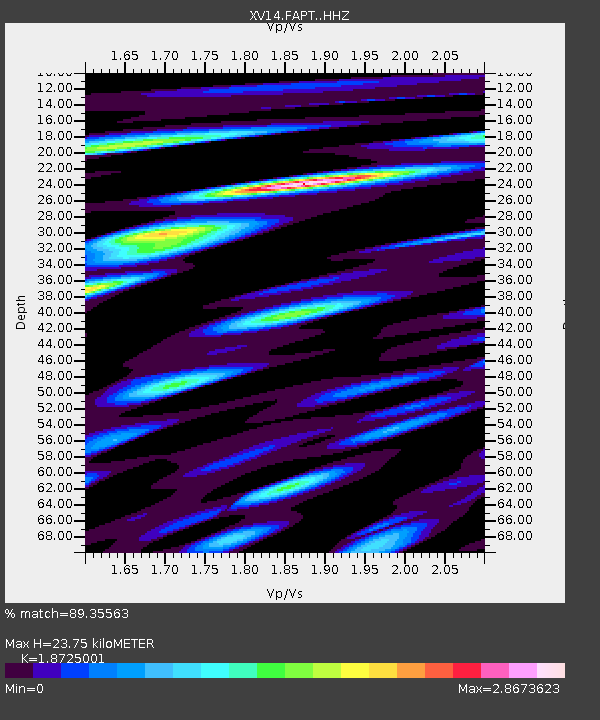
| Estimated Moho Depth: |
23.75 km |
| Estimated Crust Vp/Vs: |
1.87 |
| Assumed Crust Vp: |
6.566 km/s |
| Estimated Crust Vs: |
3.507 km/s |
| Estimated Crust Poisson's Ratio: |
0.30 |
|
| Radial Match: |
89.35563 % |
| Radial Bump: |
400 |
| Transverse Match: |
79.63495 % |
| Transverse Bump: |
400 |
| SOD ConfigId: |
7422571 |
| Insert Time: |
2019-04-21 04:24:31.435 +0000 |
| GWidth: |
2.5 |
| Max Bumps: |
400 |
| Tol: |
0.001 |
|

Signal To Noise
| Channel | StoN | STA | LTA |
| XV:FAPT: :HHZ:20151020T22:03:55.769971Z | 27.143682 | 5.4435527E-6 | 2.0054584E-7 |
| XV:FAPT: :HHN:20151020T22:03:55.769971Z | 6.6013236 | 1.633077E-6 | 2.473863E-7 |
| XV:FAPT: :HHE:20151020T22:03:55.769971Z | 7.09568 | 2.1243989E-6 | 2.9939326E-7 |
| Arrivals |
| Ps | 3.2 SECOND |
| PpPs | 10 SECOND |
| PsPs/PpSs | 13 SECOND |


