You are here: Home > Network List > ZE15 - Southern Alaska Lithosphere and Mantle Observation Network Stations List
> Station MPEN Moose Pens 2, Alaska > Earthquake Result Viewer
MPEN Moose Pens 2, Alaska - Earthquake Result Viewer
| Earthquake location: |
Vanuatu Islands |
| Earthquake latitude/longitude: |
-14.8/167.3 |
| Earthquake time(UTC): |
2015/10/20 (293) 21:52:02 GMT |
| Earthquake Depth: |
127 km |
| Earthquake Magnitude: |
7.1 MWW, 7.3 MI |
| Earthquake Catalog/Contributor: |
NEIC PDE/NEIC COMCAT |
|
| Network: |
ZE Southern Alaska Lithosphere and Mantle Observation Network |
| Station: |
MPEN Moose Pens 2, Alaska |
| Lat/Lon: |
60.74 N/150.48 W |
| Elevation: |
124 m |
|
| Distance: |
82.5 deg |
| Az: |
19.449 deg |
| Baz: |
220.944 deg |
| Ray Param: |
0.04654588 |
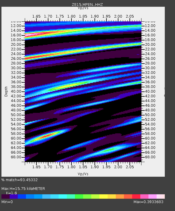
| Estimated Moho Depth: |
15.75 km |
| Estimated Crust Vp/Vs: |
1.60 |
| Assumed Crust Vp: |
6.302 km/s |
| Estimated Crust Vs: |
3.938 km/s |
| Estimated Crust Poisson's Ratio: |
0.18 |
|
| Radial Match: |
93.45332 % |
| Radial Bump: |
225 |
| Transverse Match: |
60.28598 % |
| Transverse Bump: |
400 |
| SOD ConfigId: |
7422571 |
| Insert Time: |
2019-04-21 04:25:19.109 +0000 |
| GWidth: |
2.5 |
| Max Bumps: |
400 |
| Tol: |
0.001 |
|

Signal To Noise
| Channel | StoN | STA | LTA |
| ZE:MPEN: :HHZ:20151020T22:03:39.180005Z | 3.2178974 | 8.250457E-6 | 2.5639279E-6 |
| ZE:MPEN: :HHN:20151020T22:03:39.180005Z | 1.815675 | 4.3974073E-6 | 2.4219132E-6 |
| ZE:MPEN: :HHE:20151020T22:03:39.180005Z | 0.80784506 | 3.636637E-6 | 4.501652E-6 |
| Arrivals |
| Ps | 1.5 SECOND |
| PpPs | 6.3 SECOND |
| PsPs/PpSs | 7.9 SECOND |


