You are here: Home > Network List > IC - New China Digital Seismograph Network Stations List
> Station BJT Baijiatuan, Beijing, China > Earthquake Result Viewer
BJT Baijiatuan, Beijing, China - Earthquake Result Viewer
| Earthquake location: |
Southeast Of Loyalty Islands |
| Earthquake latitude/longitude: |
-22.0/170.3 |
| Earthquake time(UTC): |
2004/05/07 (128) 01:26:42 GMT |
| Earthquake Depth: |
14 km |
| Earthquake Magnitude: |
5.7 MB, 6.2 MS, 6.3 MW, 6.2 MW |
| Earthquake Catalog/Contributor: |
WHDF/NEIC |
|
| Network: |
IC New China Digital Seismograph Network |
| Station: |
BJT Baijiatuan, Beijing, China |
| Lat/Lon: |
40.02 N/116.17 E |
| Elevation: |
197 m |
|
| Distance: |
79.7 deg |
| Az: |
320.772 deg |
| Baz: |
130.155 deg |
| Ray Param: |
0.0487993 |
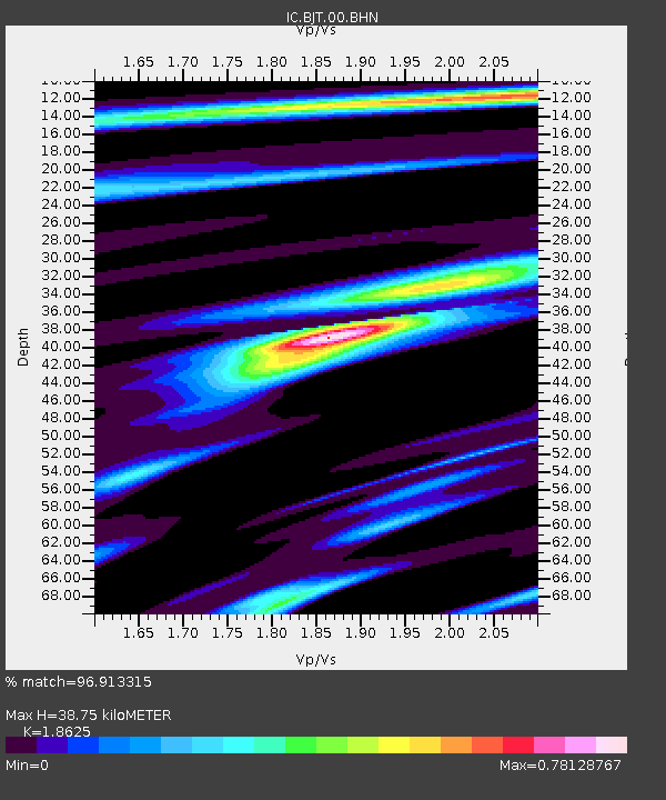
| Estimated Moho Depth: |
38.75 km |
| Estimated Crust Vp/Vs: |
1.86 |
| Assumed Crust Vp: |
6.464 km/s |
| Estimated Crust Vs: |
3.47 km/s |
| Estimated Crust Poisson's Ratio: |
0.30 |
|
| Radial Match: |
96.913315 % |
| Radial Bump: |
336 |
| Transverse Match: |
93.78374 % |
| Transverse Bump: |
400 |
| SOD ConfigId: |
2459 |
| Insert Time: |
2010-03-04 21:15:41.604 +0000 |
| GWidth: |
2.5 |
| Max Bumps: |
400 |
| Tol: |
0.001 |
|
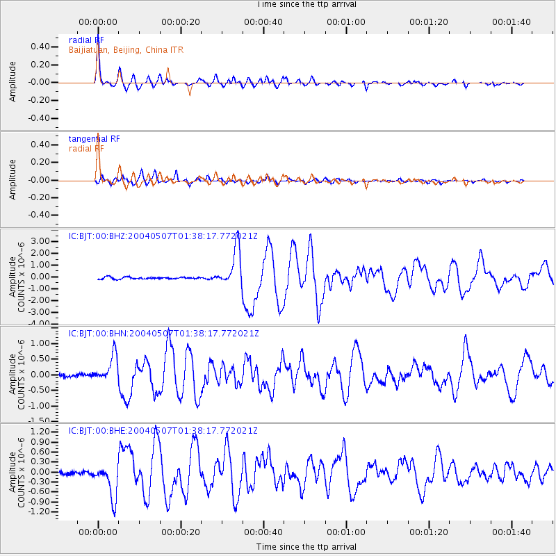
Signal To Noise
| Channel | StoN | STA | LTA |
| IC:BJT:00:BHN:20040507T01:38:17.772021Z | 7.933265 | 4.38105E-7 | 5.5223794E-8 |
| IC:BJT:00:BHE:20040507T01:38:17.772021Z | 10.377788 | 5.346301E-7 | 5.151677E-8 |
| IC:BJT:00:BHZ:20040507T01:38:17.772021Z | 21.398272 | 1.7276986E-6 | 8.07401E-8 |
| Arrivals |
| Ps | 5.3 SECOND |
| PpPs | 17 SECOND |
| PsPs/PpSs | 22 SECOND |


