You are here: Home > Network List > IC - New China Digital Seismograph Network Stations List
> Station BJT Baijiatuan, Beijing, China > Earthquake Result Viewer
BJT Baijiatuan, Beijing, China - Earthquake Result Viewer
| Earthquake location: |
Tonga Islands |
| Earthquake latitude/longitude: |
-16.8/-174.2 |
| Earthquake time(UTC): |
2004/01/25 (025) 11:43:11 GMT |
| Earthquake Depth: |
130 km |
| Earthquake Magnitude: |
6.4 MB, 6.7 MW, 6.7 MW |
| Earthquake Catalog/Contributor: |
WHDF/NEIC |
|
| Network: |
IC New China Digital Seismograph Network |
| Station: |
BJT Baijiatuan, Beijing, China |
| Lat/Lon: |
40.02 N/116.17 E |
| Elevation: |
197 m |
|
| Distance: |
85.9 deg |
| Az: |
313.795 deg |
| Baz: |
115.821 deg |
| Ray Param: |
0.044156592 |
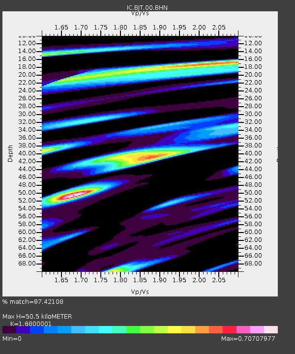
| Estimated Moho Depth: |
50.5 km |
| Estimated Crust Vp/Vs: |
1.68 |
| Assumed Crust Vp: |
6.464 km/s |
| Estimated Crust Vs: |
3.847 km/s |
| Estimated Crust Poisson's Ratio: |
0.23 |
|
| Radial Match: |
97.42108 % |
| Radial Bump: |
364 |
| Transverse Match: |
94.271965 % |
| Transverse Bump: |
357 |
| SOD ConfigId: |
2459 |
| Insert Time: |
2010-03-04 21:15:57.899 +0000 |
| GWidth: |
2.5 |
| Max Bumps: |
400 |
| Tol: |
0.001 |
|
Signal To Noise
| Channel | StoN | STA | LTA |
| IC:BJT:00:BHN:20040125T11:55:06.023015Z | 41.545837 | 2.2183115E-6 | 5.3394313E-8 |
| IC:BJT:00:BHE:20040125T11:55:06.023015Z | 64.36851 | 5.0013923E-6 | 7.769937E-8 |
| IC:BJT:00:BHZ:20040125T11:55:06.023015Z | 145.03851 | 1.4633759E-5 | 1.00895676E-7 |
| Arrivals |
| Ps | 5.4 SECOND |
| PpPs | 20 SECOND |
| PsPs/PpSs | 26 SECOND |


