You are here: Home > Network List > WI - West Indies IPGP Network Stations List
> Station MAGL Barre de l'ile, Saint louis, Marie Galante > Earthquake Result Viewer
MAGL Barre de l'ile, Saint louis, Marie Galante - Earthquake Result Viewer

| Earthquake location: |
Alaska Peninsula |
| Earthquake latitude/longitude: |
56.7/-156.5 |
| Earthquake time(UTC): |
2015/05/29 (149) 07:00:08 GMT |
| Earthquake Depth: |
62 km |
| Earthquake Magnitude: |
6.8 MWP, 6.8 MI |
| Earthquake Catalog/Contributor: |
NEIC PDE/NEIC COMCAT |
|
| Network: |
WI West Indies IPGP Network |
| Station: |
MAGL Barre de l'ile, Saint louis, Marie Galante |
| Lat/Lon: |
15.95 N/61.28 W |
| Elevation: |
150 m |
|
| Distance: |
79.7 deg |
| Az: |
76.837 deg |
| Baz: |
326.054 deg |
| Ray Param: |
0.04867771 |
| Estimated Moho Depth: |
15.0 km |
| Estimated Crust Vp/Vs: |
1.60 |
| Assumed Crust Vp: |
5.88 km/s |
| Estimated Crust Vs: |
3.67 km/s |
| Estimated Crust Poisson's Ratio: |
0.18 |
|
| Radial Match: |
83.56881 % |
| Radial Bump: |
400 |
| Transverse Match: |
71.00877 % |
| Transverse Bump: |
400 |
| SOD ConfigId: |
976571 |
| Insert Time: |
2015-06-12 07:24:13.109 +0000 |
| GWidth: |
2.5 |
| Max Bumps: |
400 |
| Tol: |
0.001 |
|
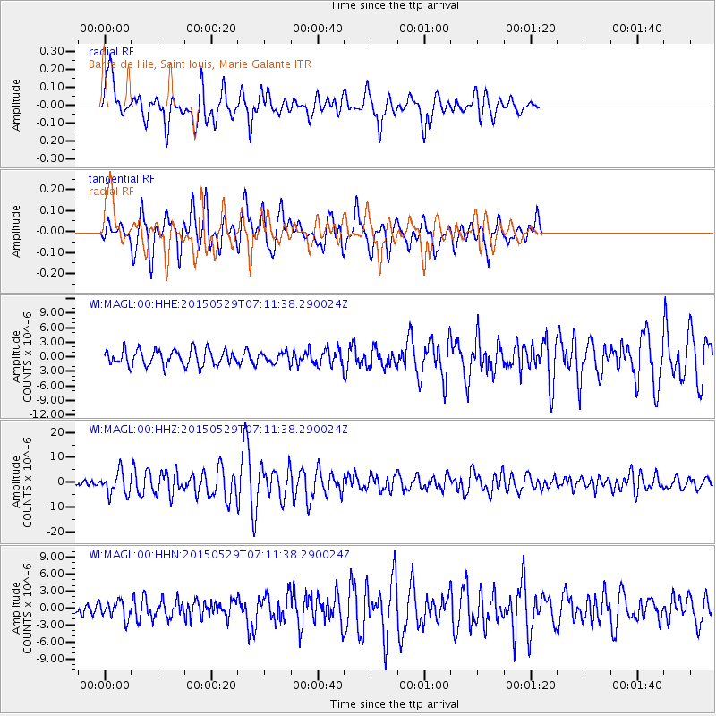
Signal To Noise
| Channel | StoN | STA | LTA |
| WI:MAGL:00:HHZ:20150529T07:11:38.290024Z | 4.452029 | 4.554023E-6 | 1.0229095E-6 |
| WI:MAGL:00:HHN:20150529T07:11:38.290024Z | 1.5625148 | 1.548592E-6 | 9.910895E-7 |
| WI:MAGL:00:HHE:20150529T07:11:38.290024Z | 0.6472743 | 1.0479579E-6 | 1.6190321E-6 |
| Arrivals |
| Ps | 1.6 SECOND |
| PpPs | 6.5 SECOND |
| PsPs/PpSs | 8.0 SECOND |


