You are here: Home > Network List > YQ13 - Study of Extension and Magmatism in Malawi and Tanzania Stations List
> Station NTHA Nthalire,Malawi > Earthquake Result Viewer
NTHA Nthalire,Malawi - Earthquake Result Viewer
| Earthquake location: |
Prince Edward Islands Region |
| Earthquake latitude/longitude: |
-45.8/37.1 |
| Earthquake time(UTC): |
2015/10/23 (296) 04:04:17 GMT |
| Earthquake Depth: |
10 km |
| Earthquake Magnitude: |
5.7 MB |
| Earthquake Catalog/Contributor: |
NEIC PDE/NEIC COMCAT |
|
| Network: |
YQ Study of Extension and Magmatism in Malawi and Tanzania |
| Station: |
NTHA Nthalire,Malawi |
| Lat/Lon: |
10.35 S/33.64 E |
| Elevation: |
1291 m |
|
| Distance: |
35.5 deg |
| Az: |
354.045 deg |
| Baz: |
175.77 deg |
| Ray Param: |
0.07721631 |
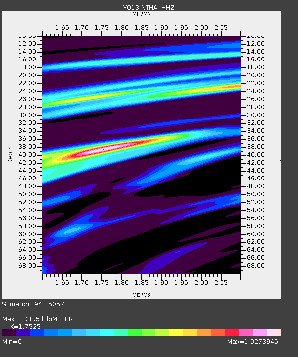
| Estimated Moho Depth: |
38.5 km |
| Estimated Crust Vp/Vs: |
1.75 |
| Assumed Crust Vp: |
6.367 km/s |
| Estimated Crust Vs: |
3.633 km/s |
| Estimated Crust Poisson's Ratio: |
0.26 |
|
| Radial Match: |
94.15057 % |
| Radial Bump: |
301 |
| Transverse Match: |
68.70789 % |
| Transverse Bump: |
400 |
| SOD ConfigId: |
7422571 |
| Insert Time: |
2019-04-21 04:36:51.538 +0000 |
| GWidth: |
2.5 |
| Max Bumps: |
400 |
| Tol: |
0.001 |
|

Signal To Noise
| Channel | StoN | STA | LTA |
| YQ:NTHA: :HHZ:20151023T04:10:43.670012Z | 6.162788 | 6.3491717E-7 | 1.0302434E-7 |
| YQ:NTHA: :HHN:20151023T04:10:43.670012Z | 5.5300145 | 5.7515035E-7 | 1.04005224E-7 |
| YQ:NTHA: :HHE:20151023T04:10:43.670012Z | 1.4911404 | 1.11658416E-7 | 7.488122E-8 |
| Arrivals |
| Ps | 4.9 SECOND |
| PpPs | 15 SECOND |
| PsPs/PpSs | 20 SECOND |


