You are here: Home > Network List > YT07 - POLENET Stations List
> Station ALYS ALYS > Earthquake Result Viewer
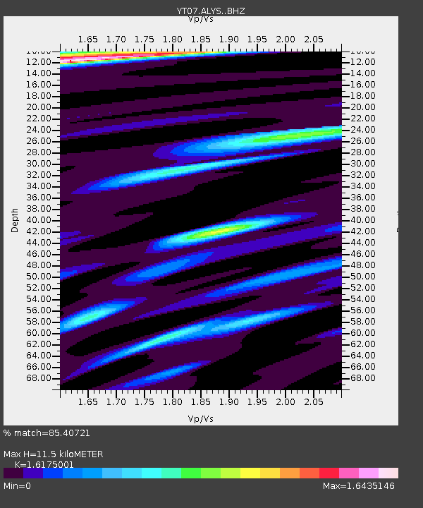
ALYS ALYS - Earthquake Result Viewer
| Earthquake location: |
Prince Edward Islands Region |
| Earthquake latitude/longitude: |
-45.8/37.1 |
| Earthquake time(UTC): |
2015/10/23 (296) 04:04:17 GMT |
| Earthquake Depth: |
10 km |
| Earthquake Magnitude: |
5.7 MB |
| Earthquake Catalog/Contributor: |
NEIC PDE/NEIC COMCAT |
|
| Network: |
YT POLENET |
| Station: |
ALYS ALYS |
| Lat/Lon: |
84.35 S/23.73 W |
| Elevation: |
2084 m |
|
| Distance: |
41.9 deg |
| Az: |
187.448 deg |
| Baz: |
66.32 deg |
| Ray Param: |
0.07352391 |
| Estimated Moho Depth: |
11.5 km |
| Estimated Crust Vp/Vs: |
1.62 |
| Assumed Crust Vp: |
6.356 km/s |
| Estimated Crust Vs: |
3.93 km/s |
| Estimated Crust Poisson's Ratio: |
0.19 |
|
| Radial Match: |
85.40721 % |
| Radial Bump: |
398 |
| Transverse Match: |
75.725525 % |
| Transverse Bump: |
400 |
| SOD ConfigId: |
7422571 |
| Insert Time: |
2019-04-21 04:36:53.923 +0000 |
| GWidth: |
2.5 |
| Max Bumps: |
400 |
| Tol: |
0.001 |
|

Signal To Noise
| Channel | StoN | STA | LTA |
| YT:ALYS: :BHZ:20151023T04:11:37.223998Z | 7.9928155 | 8.0472256E-7 | 1.0068074E-7 |
| YT:ALYS: :BHN:20151023T04:11:37.223998Z | 2.0344248 | 1.4872754E-7 | 7.3105454E-8 |
| YT:ALYS: :BHE:20151023T04:11:37.223998Z | 2.1616745 | 2.1031902E-7 | 9.729449E-8 |
| Arrivals |
| Ps | 1.2 SECOND |
| PpPs | 4.4 SECOND |
| PsPs/PpSs | 5.6 SECOND |


