You are here: Home > Network List > TA - USArray Transportable Network (new EarthScope stations) Stations List
> Station I23K Minto, Yukon-Koyukuk, AK, USA > Earthquake Result Viewer
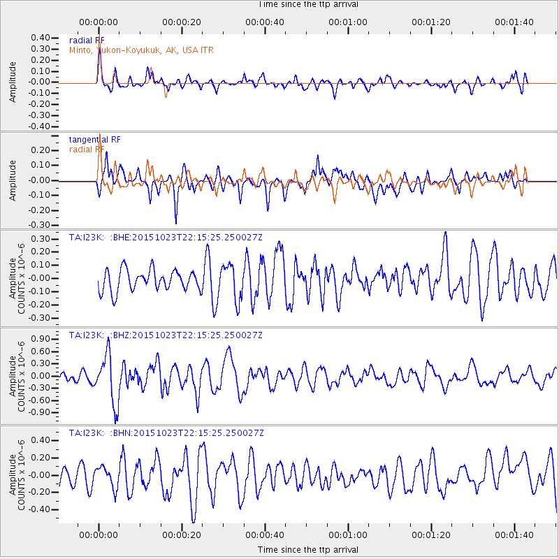
I23K Minto, Yukon-Koyukuk, AK, USA - Earthquake Result Viewer
*The percent match for this event was below the threshold and hence no stack was calculated.
| Earthquake location: |
Irian Jaya, Indonesia |
| Earthquake latitude/longitude: |
-2.1/138.2 |
| Earthquake time(UTC): |
2015/10/23 (296) 22:03:22 GMT |
| Earthquake Depth: |
10 km |
| Earthquake Magnitude: |
5.7 MWB |
| Earthquake Catalog/Contributor: |
NEIC PDE/NEIC COMCAT |
|
| Network: |
TA USArray Transportable Network (new EarthScope stations) |
| Station: |
I23K Minto, Yukon-Koyukuk, AK, USA |
| Lat/Lon: |
65.15 N/149.36 W |
| Elevation: |
149 m |
|
| Distance: |
84.6 deg |
| Az: |
23.871 deg |
| Baz: |
253.124 deg |
| Ray Param: |
$rayparam |
*The percent match for this event was below the threshold and hence was not used in the summary stack. |
|
| Radial Match: |
65.098175 % |
| Radial Bump: |
400 |
| Transverse Match: |
66.80217 % |
| Transverse Bump: |
400 |
| SOD ConfigId: |
7422571 |
| Insert Time: |
2019-04-21 04:41:05.090 +0000 |
| GWidth: |
2.5 |
| Max Bumps: |
400 |
| Tol: |
0.001 |
|
Signal To Noise
| Channel | StoN | STA | LTA |
| TA:I23K: :BHZ:20151023T22:15:25.250027Z | 5.257775 | 6.1814E-7 | 1.1756684E-7 |
| TA:I23K: :BHN:20151023T22:15:25.250027Z | 0.99600637 | 1.208808E-7 | 1.2136549E-7 |
| TA:I23K: :BHE:20151023T22:15:25.250027Z | 1.7417791 | 1.3584219E-7 | 7.799048E-8 |
| Arrivals |
| Ps | |
| PpPs | |
| PsPs/PpSs | |


