You are here: Home > Network List > TA - USArray Transportable Network (new EarthScope stations) Stations List
> Station J26L Joseph Creek, AK, USA > Earthquake Result Viewer
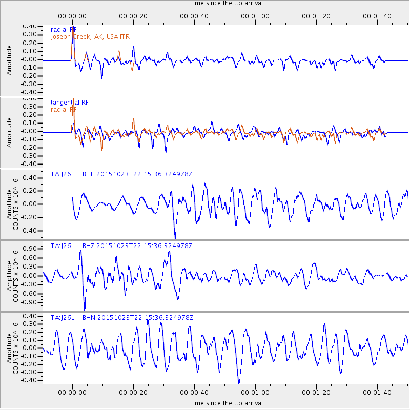
J26L Joseph Creek, AK, USA - Earthquake Result Viewer
*The percent match for this event was below the threshold and hence no stack was calculated.
| Earthquake location: |
Irian Jaya, Indonesia |
| Earthquake latitude/longitude: |
-2.1/138.2 |
| Earthquake time(UTC): |
2015/10/23 (296) 22:03:22 GMT |
| Earthquake Depth: |
10 km |
| Earthquake Magnitude: |
5.7 MWB |
| Earthquake Catalog/Contributor: |
NEIC PDE/NEIC COMCAT |
|
| Network: |
TA USArray Transportable Network (new EarthScope stations) |
| Station: |
J26L Joseph Creek, AK, USA |
| Lat/Lon: |
64.50 N/143.56 W |
| Elevation: |
1144 m |
|
| Distance: |
86.9 deg |
| Az: |
25.112 deg |
| Baz: |
258.457 deg |
| Ray Param: |
$rayparam |
*The percent match for this event was below the threshold and hence was not used in the summary stack. |
|
| Radial Match: |
75.416336 % |
| Radial Bump: |
252 |
| Transverse Match: |
46.545315 % |
| Transverse Bump: |
275 |
| SOD ConfigId: |
7422571 |
| Insert Time: |
2019-04-21 04:41:05.961 +0000 |
| GWidth: |
2.5 |
| Max Bumps: |
400 |
| Tol: |
0.001 |
|
Signal To Noise
| Channel | StoN | STA | LTA |
| TA:J26L: :BHZ:20151023T22:15:36.324978Z | 3.1225905 | 4.78175E-7 | 1.5313408E-7 |
| TA:J26L: :BHN:20151023T22:15:36.324978Z | 1.5791938 | 1.6066427E-7 | 1.0173816E-7 |
| TA:J26L: :BHE:20151023T22:15:36.324978Z | 2.3501546 | 1.9594397E-7 | 8.337493E-8 |
| Arrivals |
| Ps | |
| PpPs | |
| PsPs/PpSs | |


