You are here: Home > Network List > G - GEOSCOPE Stations List
> Station PPTF Pamatai - Papeete - Tahiti island - French Polynesia, France > Earthquake Result Viewer
PPTF Pamatai - Papeete - Tahiti island - French Polynesia, France - Earthquake Result Viewer
| Earthquake location: |
Bonin Islands, Japan Region |
| Earthquake latitude/longitude: |
27.8/140.5 |
| Earthquake time(UTC): |
2015/05/30 (150) 11:23:02 GMT |
| Earthquake Depth: |
678 km |
| Earthquake Magnitude: |
7.8 MWP, 8.5 MI |
| Earthquake Catalog/Contributor: |
NEIC PDE/NEIC COMCAT |
|
| Network: |
G GEOSCOPE |
| Station: |
PPTF Pamatai - Papeete - Tahiti island - French Polynesia, France |
| Lat/Lon: |
17.59 S/149.57 W |
| Elevation: |
705 m |
|
| Distance: |
81.4 deg |
| Az: |
115.007 deg |
| Baz: |
302.707 deg |
| Ray Param: |
0.04549349 |
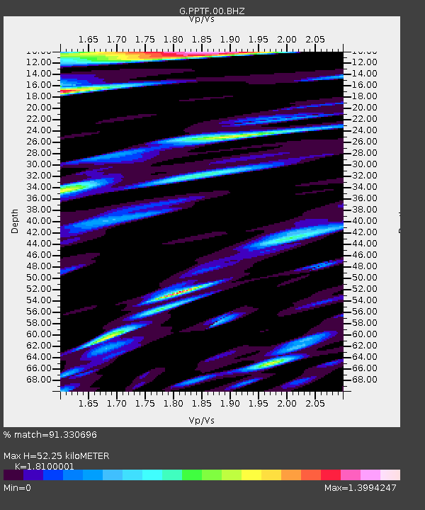
| Estimated Moho Depth: |
52.25 km |
| Estimated Crust Vp/Vs: |
1.81 |
| Assumed Crust Vp: |
4.24 km/s |
| Estimated Crust Vs: |
2.343 km/s |
| Estimated Crust Poisson's Ratio: |
0.28 |
|
| Radial Match: |
91.330696 % |
| Radial Bump: |
400 |
| Transverse Match: |
83.07398 % |
| Transverse Bump: |
400 |
| SOD ConfigId: |
976571 |
| Insert Time: |
2015-06-13 11:27:35.242 +0000 |
| GWidth: |
2.5 |
| Max Bumps: |
400 |
| Tol: |
0.001 |
|

Signal To Noise
| Channel | StoN | STA | LTA |
| G:PPTF:00:BHZ:20150530T11:33:40.249971Z | 21.173141 | 4.655168E-5 | 2.1986193E-6 |
| G:PPTF:00:BHN:20150530T11:33:40.249971Z | 3.2053094 | 8.0113705E-6 | 2.4994063E-6 |
| G:PPTF:00:BHE:20150530T11:33:40.249971Z | 6.5329213 | 1.2475283E-5 | 1.9096026E-6 |
| Arrivals |
| Ps | 10 SECOND |
| PpPs | 34 SECOND |
| PsPs/PpSs | 44 SECOND |


