You are here: Home > Network List > YT07 - POLENET Stations List
> Station RMBO RMBO > Earthquake Result Viewer
RMBO RMBO - Earthquake Result Viewer
| Earthquake location: |
Kermadec Islands, New Zealand |
| Earthquake latitude/longitude: |
-29.3/-177.8 |
| Earthquake time(UTC): |
2015/10/25 (298) 14:58:57 GMT |
| Earthquake Depth: |
10 km |
| Earthquake Magnitude: |
5.5 MB, 5.7 MWB |
| Earthquake Catalog/Contributor: |
NEIC PDE/NEIC COMCAT |
|
| Network: |
YT POLENET |
| Station: |
RMBO RMBO |
| Lat/Lon: |
83.87 S/66.40 W |
| Elevation: |
800 m |
|
| Distance: |
63.2 deg |
| Az: |
173.565 deg |
| Baz: |
245.584 deg |
| Ray Param: |
0.059706517 |
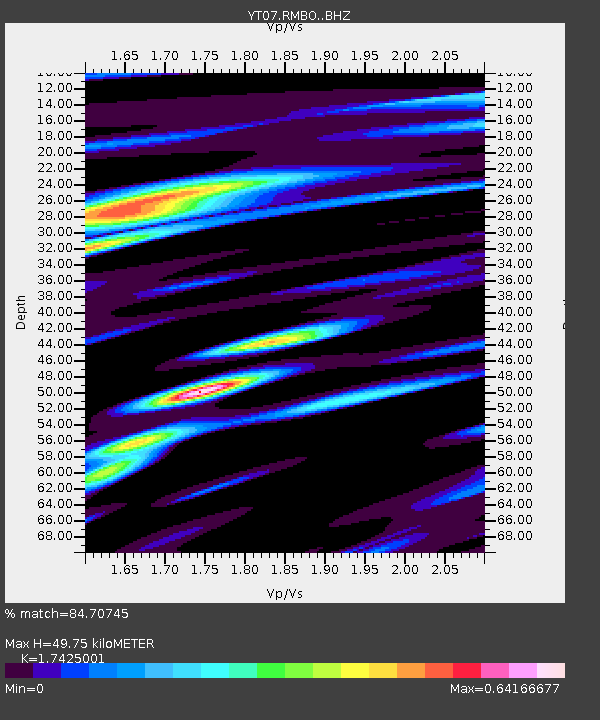
| Estimated Moho Depth: |
49.75 km |
| Estimated Crust Vp/Vs: |
1.74 |
| Assumed Crust Vp: |
6.356 km/s |
| Estimated Crust Vs: |
3.648 km/s |
| Estimated Crust Poisson's Ratio: |
0.25 |
|
| Radial Match: |
84.70745 % |
| Radial Bump: |
367 |
| Transverse Match: |
66.999084 % |
| Transverse Bump: |
400 |
| SOD ConfigId: |
7422571 |
| Insert Time: |
2019-04-21 04:54:25.706 +0000 |
| GWidth: |
2.5 |
| Max Bumps: |
400 |
| Tol: |
0.001 |
|

Signal To Noise
| Channel | StoN | STA | LTA |
| YT:RMBO: :BHZ:20151025T15:08:55.000017Z | 3.9362893 | 2.834033E-7 | 7.1997576E-8 |
| YT:RMBO: :BHN:20151025T15:08:55.000017Z | 1.01316 | 1.1106567E-7 | 1.0962303E-7 |
| YT:RMBO: :BHE:20151025T15:08:55.000017Z | 3.400523 | 1.568447E-7 | 4.61237E-8 |
| Arrivals |
| Ps | 6.1 SECOND |
| PpPs | 21 SECOND |
| PsPs/PpSs | 27 SECOND |


