You are here: Home > Network List > AK - Alaska Regional Network Stations List
> Station GRIN Grindle Hills, AK, USA > Earthquake Result Viewer
GRIN Grindle Hills, AK, USA - Earthquake Result Viewer
| Earthquake location: |
Hindu Kush Region, Afghanistan |
| Earthquake latitude/longitude: |
36.4/70.7 |
| Earthquake time(UTC): |
2015/10/26 (299) 09:09:32 GMT |
| Earthquake Depth: |
212 km |
| Earthquake Magnitude: |
7.5 MWW, 7.5 MWB |
| Earthquake Catalog/Contributor: |
NEIC PDE/NEIC COMCAT |
|
| Network: |
AK Alaska Regional Network |
| Station: |
GRIN Grindle Hills, AK, USA |
| Lat/Lon: |
60.28 N/143.32 W |
| Elevation: |
625 m |
|
| Distance: |
79.6 deg |
| Az: |
16.47 deg |
| Baz: |
332.688 deg |
| Ray Param: |
0.048286937 |
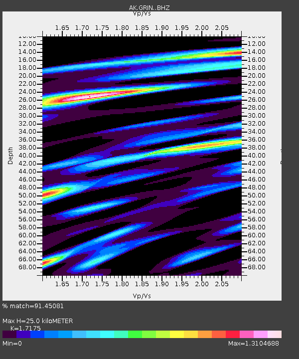
| Estimated Moho Depth: |
25.0 km |
| Estimated Crust Vp/Vs: |
1.72 |
| Assumed Crust Vp: |
6.566 km/s |
| Estimated Crust Vs: |
3.823 km/s |
| Estimated Crust Poisson's Ratio: |
0.24 |
|
| Radial Match: |
91.45081 % |
| Radial Bump: |
373 |
| Transverse Match: |
82.28564 % |
| Transverse Bump: |
400 |
| SOD ConfigId: |
7422571 |
| Insert Time: |
2019-04-21 04:55:55.221 +0000 |
| GWidth: |
2.5 |
| Max Bumps: |
400 |
| Tol: |
0.001 |
|

Signal To Noise
| Channel | StoN | STA | LTA |
| AK:GRIN: :BHZ:20151026T09:20:45.127981Z | 3.8681035 | 3.19077E-6 | 8.2489265E-7 |
| AK:GRIN: :BHN:20151026T09:20:45.127981Z | 2.5361562 | 2.0384848E-6 | 8.0376947E-7 |
| AK:GRIN: :BHE:20151026T09:20:45.127981Z | 3.1004918 | 1.561673E-6 | 5.0368556E-7 |
| Arrivals |
| Ps | 2.8 SECOND |
| PpPs | 10 SECOND |
| PsPs/PpSs | 13 SECOND |


