You are here: Home > Network List > AK - Alaska Regional Network Stations List
> Station KOTZ Kotzebue, AK, USA > Earthquake Result Viewer
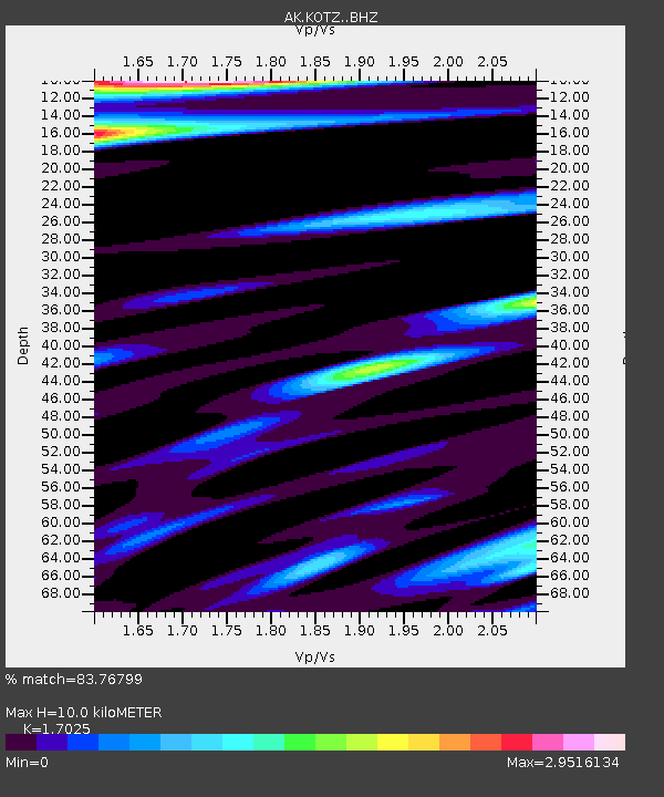
KOTZ Kotzebue, AK, USA - Earthquake Result Viewer
| Earthquake location: |
Hindu Kush Region, Afghanistan |
| Earthquake latitude/longitude: |
36.4/70.7 |
| Earthquake time(UTC): |
2015/10/26 (299) 09:09:32 GMT |
| Earthquake Depth: |
212 km |
| Earthquake Magnitude: |
7.5 MWW, 7.5 MWB |
| Earthquake Catalog/Contributor: |
NEIC PDE/NEIC COMCAT |
|
| Network: |
AK Alaska Regional Network |
| Station: |
KOTZ Kotzebue, AK, USA |
| Lat/Lon: |
66.90 N/162.60 W |
| Elevation: |
10 m |
|
| Distance: |
69.3 deg |
| Az: |
19.774 deg |
| Baz: |
316.271 deg |
| Ray Param: |
0.05512165 |
| Estimated Moho Depth: |
10.0 km |
| Estimated Crust Vp/Vs: |
1.70 |
| Assumed Crust Vp: |
6.276 km/s |
| Estimated Crust Vs: |
3.686 km/s |
| Estimated Crust Poisson's Ratio: |
0.24 |
|
| Radial Match: |
83.76799 % |
| Radial Bump: |
390 |
| Transverse Match: |
78.558105 % |
| Transverse Bump: |
388 |
| SOD ConfigId: |
7422571 |
| Insert Time: |
2019-04-21 04:56:04.174 +0000 |
| GWidth: |
2.5 |
| Max Bumps: |
400 |
| Tol: |
0.001 |
|

Signal To Noise
| Channel | StoN | STA | LTA |
| AK:KOTZ: :BHZ:20151026T09:19:45.867971Z | 4.9541554 | 3.568863E-6 | 7.2037767E-7 |
| AK:KOTZ: :BHN:20151026T09:19:45.867971Z | 1.0723115 | 1.5396012E-6 | 1.4357779E-6 |
| AK:KOTZ: :BHE:20151026T09:19:45.867971Z | 0.9307545 | 1.9579863E-6 | 2.1036549E-6 |
| Arrivals |
| Ps | 1.2 SECOND |
| PpPs | 4.2 SECOND |
| PsPs/PpSs | 5.3 SECOND |


