You are here: Home > Network List > GS - US Geological Survey Networks Stations List
> Station KAN13 Rinehart Farm, , CA, USA > Earthquake Result Viewer
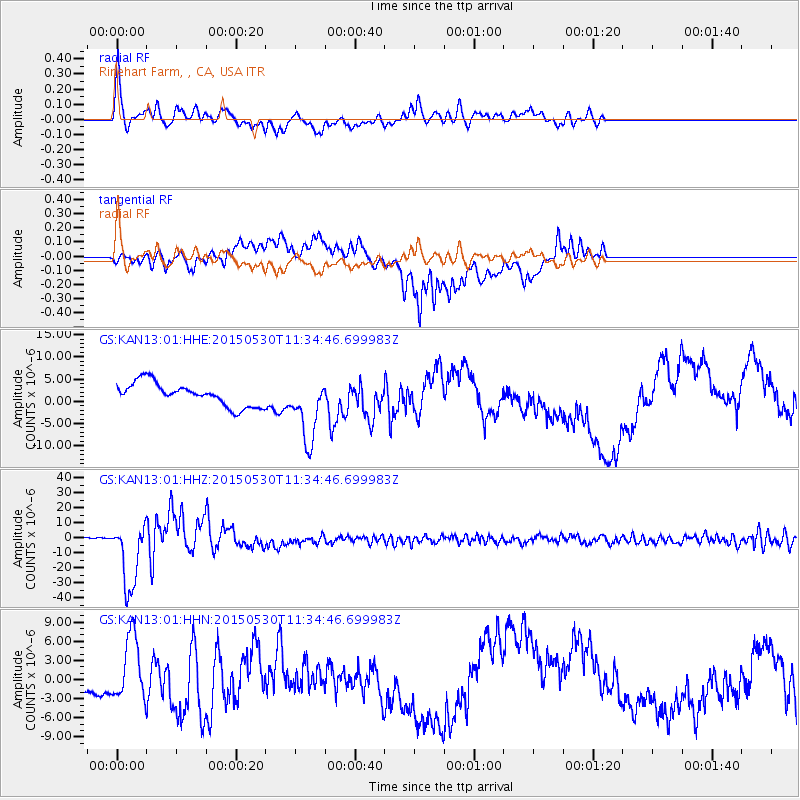
KAN13 Rinehart Farm, , CA, USA - Earthquake Result Viewer
*The percent match for this event was below the threshold and hence no stack was calculated.
| Earthquake location: |
Bonin Islands, Japan Region |
| Earthquake latitude/longitude: |
27.8/140.5 |
| Earthquake time(UTC): |
2015/05/30 (150) 11:23:02 GMT |
| Earthquake Depth: |
678 km |
| Earthquake Magnitude: |
7.8 MWP, 8.5 MI |
| Earthquake Catalog/Contributor: |
NEIC PDE/NEIC COMCAT |
|
| Network: |
GS US Geological Survey Networks |
| Station: |
KAN13 Rinehart Farm, , CA, USA |
| Lat/Lon: |
37.01 N/97.48 W |
| Elevation: |
340 m |
|
| Distance: |
95.6 deg |
| Az: |
42.988 deg |
| Baz: |
311.026 deg |
| Ray Param: |
$rayparam |
*The percent match for this event was below the threshold and hence was not used in the summary stack. |
|
| Radial Match: |
77.02629 % |
| Radial Bump: |
400 |
| Transverse Match: |
60.629604 % |
| Transverse Bump: |
400 |
| SOD ConfigId: |
976571 |
| Insert Time: |
2015-06-13 11:28:04.466 +0000 |
| GWidth: |
2.5 |
| Max Bumps: |
400 |
| Tol: |
0.001 |
|
Signal To Noise
| Channel | StoN | STA | LTA |
| GS:KAN13:01:HHZ:20150530T11:34:46.699983Z | 45.103317 | 2.2022483E-5 | 4.8826746E-7 |
| GS:KAN13:01:HHN:20150530T11:34:46.699983Z | 5.0848656 | 5.4826783E-6 | 1.0782346E-6 |
| GS:KAN13:01:HHE:20150530T11:34:46.699983Z | 2.7842298 | 7.2333564E-6 | 2.597974E-6 |
| Arrivals |
| Ps | |
| PpPs | |
| PsPs/PpSs | |


