You are here: Home > Network List > AK - Alaska Regional Network Stations List
> Station SUCK Suckling Hills, AK, USA > Earthquake Result Viewer
SUCK Suckling Hills, AK, USA - Earthquake Result Viewer
| Earthquake location: |
Hindu Kush Region, Afghanistan |
| Earthquake latitude/longitude: |
36.4/70.7 |
| Earthquake time(UTC): |
2015/10/26 (299) 09:09:32 GMT |
| Earthquake Depth: |
212 km |
| Earthquake Magnitude: |
7.5 MWW, 7.5 MWB |
| Earthquake Catalog/Contributor: |
NEIC PDE/NEIC COMCAT |
|
| Network: |
AK Alaska Regional Network |
| Station: |
SUCK Suckling Hills, AK, USA |
| Lat/Lon: |
60.07 N/143.78 W |
| Elevation: |
467 m |
|
| Distance: |
79.7 deg |
| Az: |
16.775 deg |
| Baz: |
332.346 deg |
| Ray Param: |
0.048232973 |
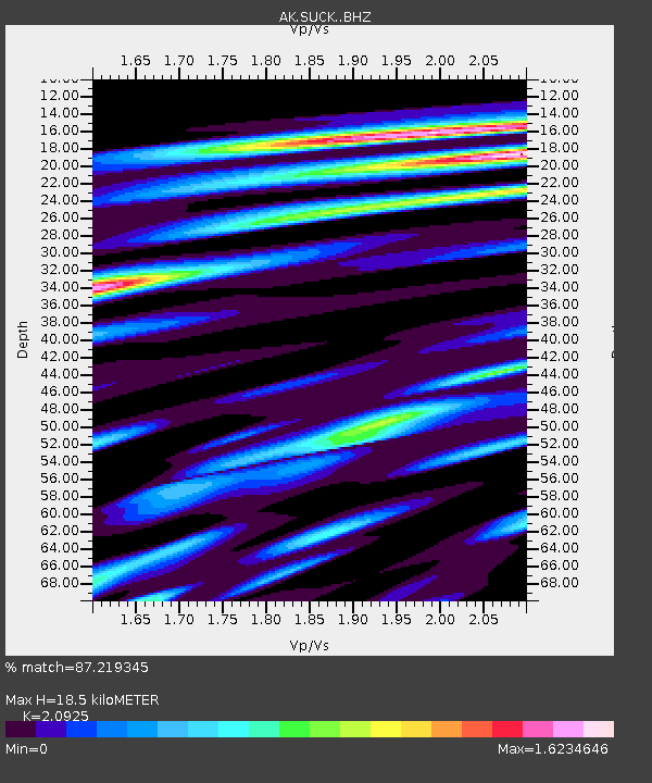
| Estimated Moho Depth: |
18.5 km |
| Estimated Crust Vp/Vs: |
2.09 |
| Assumed Crust Vp: |
6.566 km/s |
| Estimated Crust Vs: |
3.138 km/s |
| Estimated Crust Poisson's Ratio: |
0.35 |
|
| Radial Match: |
87.219345 % |
| Radial Bump: |
400 |
| Transverse Match: |
78.5479 % |
| Transverse Bump: |
400 |
| SOD ConfigId: |
7422571 |
| Insert Time: |
2019-04-21 04:56:31.898 +0000 |
| GWidth: |
2.5 |
| Max Bumps: |
400 |
| Tol: |
0.001 |
|

Signal To Noise
| Channel | StoN | STA | LTA |
| AK:SUCK: :BHZ:20151026T09:20:45.548025Z | 1.6668061 | 2.6861217E-6 | 1.6115382E-6 |
| AK:SUCK: :BHN:20151026T09:20:45.548025Z | 0.8489103 | 1.2294695E-6 | 1.4482914E-6 |
| AK:SUCK: :BHE:20151026T09:20:45.548025Z | 2.0126963 | 1.8453628E-6 | 9.168611E-7 |
| Arrivals |
| Ps | 3.2 SECOND |
| PpPs | 8.5 SECOND |
| PsPs/PpSs | 12 SECOND |


