You are here: Home > Network List > II - Global Seismograph Network (GSN - IRIS/IDA) Stations List
> Station NIL Nilore, Pakistan > Earthquake Result Viewer
NIL Nilore, Pakistan - Earthquake Result Viewer
| Earthquake location: |
Bonin Islands, Japan Region |
| Earthquake latitude/longitude: |
27.8/140.5 |
| Earthquake time(UTC): |
2015/05/30 (150) 11:23:02 GMT |
| Earthquake Depth: |
678 km |
| Earthquake Magnitude: |
7.8 MWP, 8.5 MI |
| Earthquake Catalog/Contributor: |
NEIC PDE/NEIC COMCAT |
|
| Network: |
II Global Seismograph Network (GSN - IRIS/IDA) |
| Station: |
NIL Nilore, Pakistan |
| Lat/Lon: |
33.65 N/73.27 E |
| Elevation: |
629 m |
|
| Distance: |
57.2 deg |
| Az: |
293.755 deg |
| Baz: |
76.35 deg |
| Ray Param: |
0.06068208 |
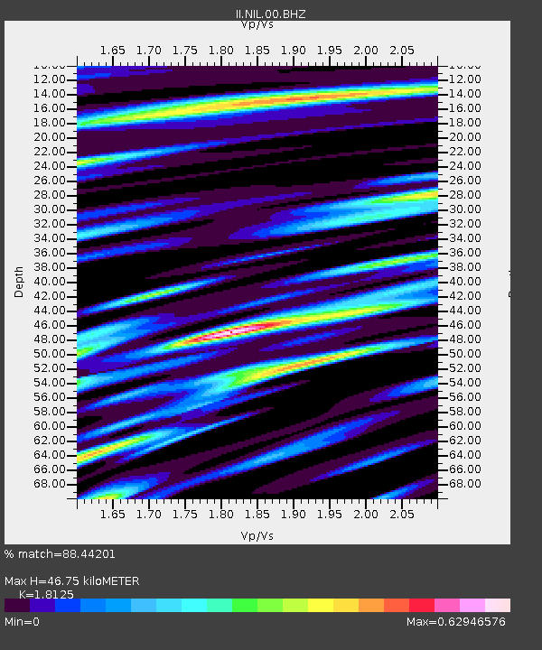
| Estimated Moho Depth: |
46.75 km |
| Estimated Crust Vp/Vs: |
1.81 |
| Assumed Crust Vp: |
6.242 km/s |
| Estimated Crust Vs: |
3.444 km/s |
| Estimated Crust Poisson's Ratio: |
0.28 |
|
| Radial Match: |
88.44201 % |
| Radial Bump: |
400 |
| Transverse Match: |
87.60825 % |
| Transverse Bump: |
400 |
| SOD ConfigId: |
976571 |
| Insert Time: |
2015-06-13 11:28:27.620 +0000 |
| GWidth: |
2.5 |
| Max Bumps: |
400 |
| Tol: |
0.001 |
|
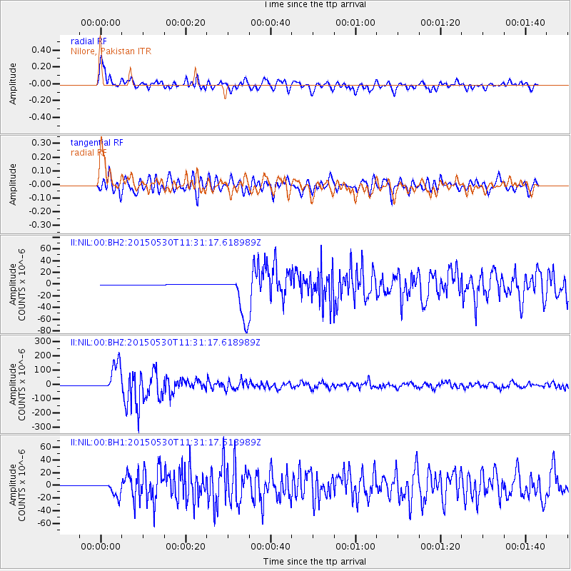
Signal To Noise
| Channel | StoN | STA | LTA |
| II:NIL:00:BHZ:20150530T11:31:17.618989Z | 120.37575 | 1.01683574E-4 | 8.447181E-7 |
| II:NIL:00:BH1:20150530T11:31:17.618989Z | 49.159504 | 1.1217734E-5 | 2.2819053E-7 |
| II:NIL:00:BH2:20150530T11:31:17.618989Z | 62.713142 | 3.9620583E-5 | 6.317748E-7 |
| Arrivals |
| Ps | 6.3 SECOND |
| PpPs | 20 SECOND |
| PsPs/PpSs | 27 SECOND |


