You are here: Home > Network List > CB - China National Seismic Network Stations List
> Station XLT Xilinhaote,Neimeng Province > Earthquake Result Viewer
XLT Xilinhaote,Neimeng Province - Earthquake Result Viewer
| Earthquake location: |
Hindu Kush Region, Afghanistan |
| Earthquake latitude/longitude: |
36.4/70.7 |
| Earthquake time(UTC): |
2015/10/26 (299) 09:09:32 GMT |
| Earthquake Depth: |
212 km |
| Earthquake Magnitude: |
7.5 MWW, 7.5 MWB |
| Earthquake Catalog/Contributor: |
NEIC PDE/NEIC COMCAT |
|
| Network: |
CB China National Seismic Network |
| Station: |
XLT Xilinhaote,Neimeng Province |
| Lat/Lon: |
43.90 N/116.08 E |
| Elevation: |
1030 m |
|
| Distance: |
35.1 deg |
| Az: |
63.469 deg |
| Baz: |
273.592 deg |
| Ray Param: |
0.076617874 |
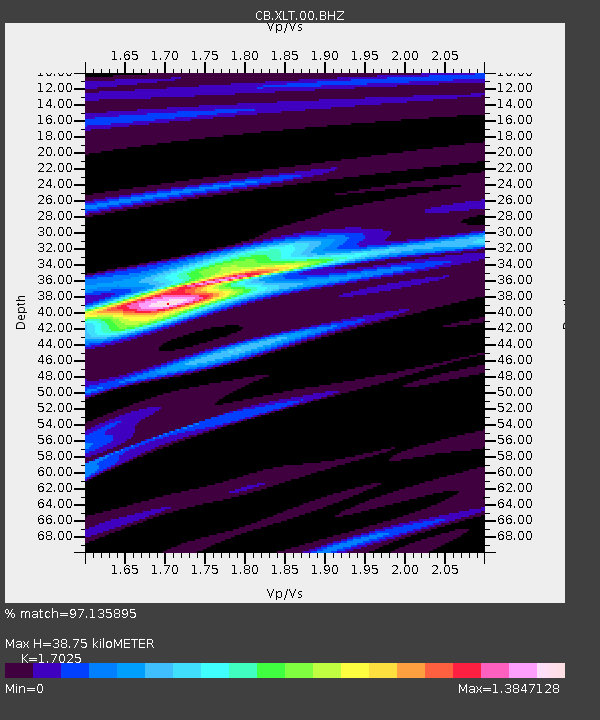
| Estimated Moho Depth: |
38.75 km |
| Estimated Crust Vp/Vs: |
1.70 |
| Assumed Crust Vp: |
6.459 km/s |
| Estimated Crust Vs: |
3.794 km/s |
| Estimated Crust Poisson's Ratio: |
0.24 |
|
| Radial Match: |
97.135895 % |
| Radial Bump: |
259 |
| Transverse Match: |
85.63209 % |
| Transverse Bump: |
400 |
| SOD ConfigId: |
7422571 |
| Insert Time: |
2019-04-21 04:57:28.349 +0000 |
| GWidth: |
2.5 |
| Max Bumps: |
400 |
| Tol: |
0.001 |
|

Signal To Noise
| Channel | StoN | STA | LTA |
| CB:XLT:00:BHZ:20151026T09:15:35.119985Z | 2.6875377 | 1.5858659E-6 | 5.900813E-7 |
| CB:XLT:00:BHN:20151026T09:15:35.119985Z | 1.3200982 | 1.816572E-7 | 1.3760886E-7 |
| CB:XLT:00:BHE:20151026T09:15:35.119985Z | 2.628032 | 1.0527253E-6 | 4.0057554E-7 |
| Arrivals |
| Ps | 4.6 SECOND |
| PpPs | 15 SECOND |
| PsPs/PpSs | 20 SECOND |


