You are here: Home > Network List > IU - Global Seismograph Network (GSN - IRIS/USGS) Stations List
> Station AFI Afiamalu, Samoa > Earthquake Result Viewer
AFI Afiamalu, Samoa - Earthquake Result Viewer
| Earthquake location: |
Bonin Islands, Japan Region |
| Earthquake latitude/longitude: |
27.8/140.5 |
| Earthquake time(UTC): |
2015/05/30 (150) 11:23:02 GMT |
| Earthquake Depth: |
678 km |
| Earthquake Magnitude: |
7.8 MWP, 8.5 MI |
| Earthquake Catalog/Contributor: |
NEIC PDE/NEIC COMCAT |
|
| Network: |
IU Global Seismograph Network (GSN - IRIS/USGS) |
| Station: |
AFI Afiamalu, Samoa |
| Lat/Lon: |
13.91 S/171.78 W |
| Elevation: |
706 m |
|
| Distance: |
62.1 deg |
| Az: |
125.624 deg |
| Baz: |
312.154 deg |
| Ray Param: |
0.057672784 |
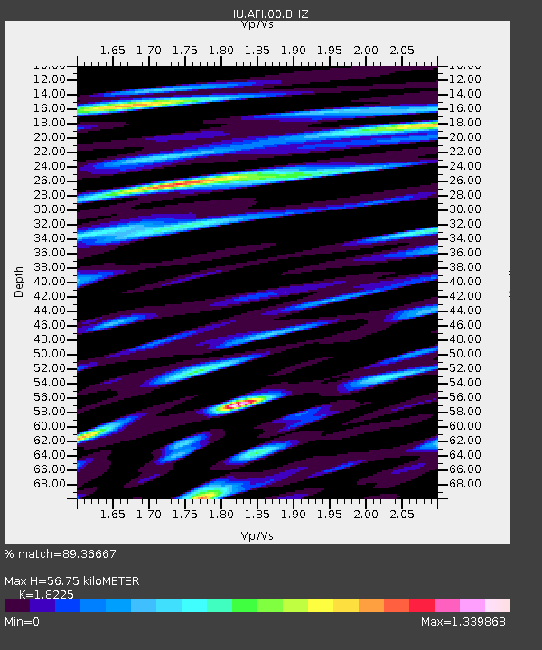
| Estimated Moho Depth: |
56.75 km |
| Estimated Crust Vp/Vs: |
1.82 |
| Assumed Crust Vp: |
4.24 km/s |
| Estimated Crust Vs: |
2.326 km/s |
| Estimated Crust Poisson's Ratio: |
0.28 |
|
| Radial Match: |
89.36667 % |
| Radial Bump: |
400 |
| Transverse Match: |
85.57447 % |
| Transverse Bump: |
400 |
| SOD ConfigId: |
976571 |
| Insert Time: |
2015-06-13 11:28:35.890 +0000 |
| GWidth: |
2.5 |
| Max Bumps: |
400 |
| Tol: |
0.001 |
|
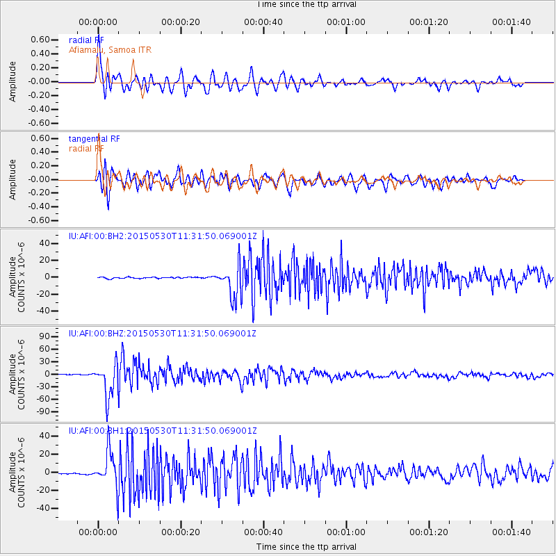
Signal To Noise
| Channel | StoN | STA | LTA |
| IU:AFI:00:BHZ:20150530T11:31:50.069001Z | 45.09721 | 4.2169308E-5 | 9.350757E-7 |
| IU:AFI:00:BH1:20150530T11:31:50.069001Z | 18.702433 | 2.0787209E-5 | 1.1114709E-6 |
| IU:AFI:00:BH2:20150530T11:31:50.069001Z | 26.503492 | 2.0610678E-5 | 7.7765895E-7 |
| Arrivals |
| Ps | 11 SECOND |
| PpPs | 37 SECOND |
| PsPs/PpSs | 48 SECOND |


