You are here: Home > Network List > IC - New China Digital Seismograph Network Stations List
> Station BJT Baijiatuan, Beijing, China > Earthquake Result Viewer
BJT Baijiatuan, Beijing, China - Earthquake Result Viewer
| Earthquake location: |
Tonga Islands |
| Earthquake latitude/longitude: |
-20.8/-173.3 |
| Earthquake time(UTC): |
2008/06/26 (178) 21:19:15 GMT |
| Earthquake Depth: |
38 km |
| Earthquake Magnitude: |
6.0 MB, 5.8 MS, 6.2 MW, 6.1 MW |
| Earthquake Catalog/Contributor: |
WHDF/NEIC |
|
| Network: |
IC New China Digital Seismograph Network |
| Station: |
BJT Baijiatuan, Beijing, China |
| Lat/Lon: |
40.02 N/116.17 E |
| Elevation: |
197 m |
|
| Distance: |
89.2 deg |
| Az: |
313.619 deg |
| Baz: |
118.095 deg |
| Ray Param: |
0.04198306 |
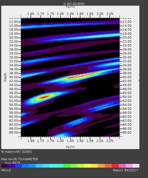
| Estimated Moho Depth: |
38.75 km |
| Estimated Crust Vp/Vs: |
1.91 |
| Assumed Crust Vp: |
6.464 km/s |
| Estimated Crust Vs: |
3.388 km/s |
| Estimated Crust Poisson's Ratio: |
0.31 |
|
| Radial Match: |
97.02893 % |
| Radial Bump: |
294 |
| Transverse Match: |
95.180214 % |
| Transverse Bump: |
302 |
| SOD ConfigId: |
2504 |
| Insert Time: |
2010-03-04 21:19:44.621 +0000 |
| GWidth: |
2.5 |
| Max Bumps: |
400 |
| Tol: |
0.001 |
|
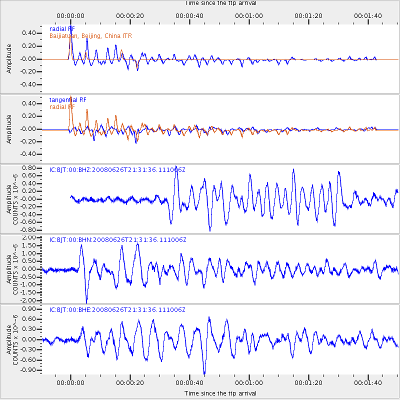
Signal To Noise
| Channel | StoN | STA | LTA |
| IC:BJT:00:BHN:20080626T21:31:36.111006Z | 8.5139265 | 6.026E-7 | 7.077814E-8 |
| IC:BJT:00:BHE:20080626T21:31:36.111006Z | 3.0471377 | 1.3721865E-7 | 4.503198E-8 |
| IC:BJT:00:BHZ:20080626T21:31:36.111006Z | 5.700185 | 2.471884E-7 | 4.336498E-8 |
| Arrivals |
| Ps | 5.5 SECOND |
| PpPs | 17 SECOND |
| PsPs/PpSs | 23 SECOND |


