You are here: Home > Network List > PF - Volcanologic Network of Piton de Fournaise-OVPF Stations List
> Station CAM College de Cambuston > Earthquake Result Viewer
CAM College de Cambuston - Earthquake Result Viewer
| Earthquake location: |
Hindu Kush Region, Afghanistan |
| Earthquake latitude/longitude: |
36.4/70.7 |
| Earthquake time(UTC): |
2015/10/26 (299) 09:09:32 GMT |
| Earthquake Depth: |
212 km |
| Earthquake Magnitude: |
7.5 MWW, 7.5 MWB |
| Earthquake Catalog/Contributor: |
NEIC PDE/NEIC COMCAT |
|
| Network: |
PF Volcanologic Network of Piton de Fournaise-OVPF |
| Station: |
CAM College de Cambuston |
| Lat/Lon: |
20.93 S/55.65 E |
| Elevation: |
15 m |
|
| Distance: |
58.8 deg |
| Az: |
196.506 deg |
| Baz: |
14.186 deg |
| Ray Param: |
0.06190034 |
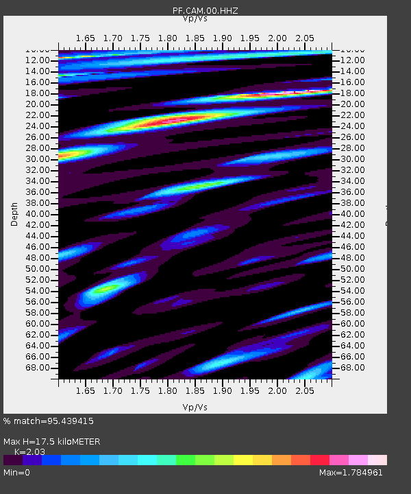
| Estimated Moho Depth: |
17.5 km |
| Estimated Crust Vp/Vs: |
2.03 |
| Assumed Crust Vp: |
4.73 km/s |
| Estimated Crust Vs: |
2.33 km/s |
| Estimated Crust Poisson's Ratio: |
0.34 |
|
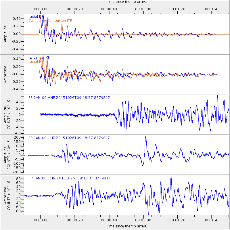
| Radial Match: |
95.439415 % |
| Radial Bump: |
400 |
| Transverse Match: |
90.99931 % |
| Transverse Bump: |
400 |
| SOD ConfigId: |
7422571 |
| Insert Time: |
2019-04-21 04:59:59.048 +0000 |
| GWidth: |
2.5 |
| Max Bumps: |
400 |
| Tol: |
0.001 |
|
Signal To Noise
| Channel | StoN | STA | LTA |
| PF:CAM:00:HHZ:20151026T09:18:37.877981Z | 1.2845439 | 2.2132008E-6 | 1.7229468E-6 |
| PF:CAM:00:HHN:20151026T09:18:37.877981Z | 0.7201922 | 1.370275E-6 | 1.9026518E-6 |
| PF:CAM:00:HHE:20151026T09:18:37.877981Z | 1.7818037 | 3.0754165E-6 | 1.7260131E-6 |
| Arrivals |
| Ps | 3.9 SECOND |
| PpPs | 11 SECOND |
| PsPs/PpSs | 15 SECOND |


