You are here: Home > Network List > RV - Regional Alberta Seismic Observatory for Earthquake Studies Network Stations List
> Station HILA High Level, AB > Earthquake Result Viewer
HILA High Level, AB - Earthquake Result Viewer
| Earthquake location: |
Hindu Kush Region, Afghanistan |
| Earthquake latitude/longitude: |
36.4/70.7 |
| Earthquake time(UTC): |
2015/10/26 (299) 09:09:32 GMT |
| Earthquake Depth: |
212 km |
| Earthquake Magnitude: |
7.5 MWW, 7.5 MWB |
| Earthquake Catalog/Contributor: |
NEIC PDE/NEIC COMCAT |
|
| Network: |
RV Regional Alberta Seismic Observatory for Earthquake Studies Network |
| Station: |
HILA High Level, AB |
| Lat/Lon: |
58.56 N/117.02 W |
| Elevation: |
329 m |
|
| Distance: |
85.1 deg |
| Az: |
4.062 deg |
| Baz: |
353.745 deg |
| Ray Param: |
0.044471186 |
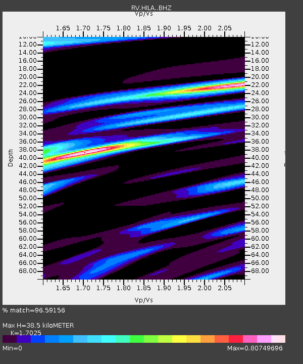
| Estimated Moho Depth: |
38.5 km |
| Estimated Crust Vp/Vs: |
1.70 |
| Assumed Crust Vp: |
6.498 km/s |
| Estimated Crust Vs: |
3.816 km/s |
| Estimated Crust Poisson's Ratio: |
0.24 |
|
| Radial Match: |
96.59156 % |
| Radial Bump: |
347 |
| Transverse Match: |
80.50134 % |
| Transverse Bump: |
400 |
| SOD ConfigId: |
7422571 |
| Insert Time: |
2019-04-21 05:00:28.969 +0000 |
| GWidth: |
2.5 |
| Max Bumps: |
400 |
| Tol: |
0.001 |
|

Signal To Noise
| Channel | StoN | STA | LTA |
| RV:HILA: :BHZ:20151026T09:21:13.400015Z | 4.025691 | 4.753171E-5 | 1.1807094E-5 |
| RV:HILA: :BHN:20151026T09:21:13.400015Z | 1.3032075 | 2.2665376E-5 | 1.7391993E-5 |
| RV:HILA: :BHE:20151026T09:21:13.400015Z | 0.47308323 | 7.2188022E-6 | 1.5259053E-5 |
| Arrivals |
| Ps | 4.3 SECOND |
| PpPs | 16 SECOND |
| PsPs/PpSs | 20 SECOND |


