You are here: Home > Network List > S - Seismographs in Schools Projects Stations List
> Station AUKAT Katherine High School, NT > Earthquake Result Viewer
AUKAT Katherine High School, NT - Earthquake Result Viewer
| Earthquake location: |
Hindu Kush Region, Afghanistan |
| Earthquake latitude/longitude: |
36.4/70.7 |
| Earthquake time(UTC): |
2015/10/26 (299) 09:09:32 GMT |
| Earthquake Depth: |
212 km |
| Earthquake Magnitude: |
7.5 MWW, 7.5 MWB |
| Earthquake Catalog/Contributor: |
NEIC PDE/NEIC COMCAT |
|
| Network: |
S Seismographs in Schools Projects |
| Station: |
AUKAT Katherine High School, NT |
| Lat/Lon: |
14.46 S/132.28 E |
| Elevation: |
122 m |
|
| Distance: |
77.0 deg |
| Az: |
119.037 deg |
| Baz: |
313.299 deg |
| Ray Param: |
0.050073795 |
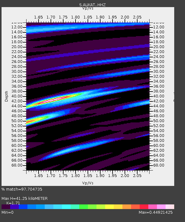
| Estimated Moho Depth: |
41.25 km |
| Estimated Crust Vp/Vs: |
1.71 |
| Assumed Crust Vp: |
6.61 km/s |
| Estimated Crust Vs: |
3.865 km/s |
| Estimated Crust Poisson's Ratio: |
0.24 |
|
| Radial Match: |
97.704735 % |
| Radial Bump: |
263 |
| Transverse Match: |
89.24956 % |
| Transverse Bump: |
400 |
| SOD ConfigId: |
7422571 |
| Insert Time: |
2019-04-21 05:00:37.196 +0000 |
| GWidth: |
2.5 |
| Max Bumps: |
400 |
| Tol: |
0.001 |
|

Signal To Noise
| Channel | StoN | STA | LTA |
| S:AUKAT: :HHZ:20151026T09:20:30.869985Z | 9.80117 | 2.1027356E-6 | 2.1453926E-7 |
| S:AUKAT: :HHN:20151026T09:20:30.869985Z | 3.9422548 | 8.84164E-7 | 2.2427876E-7 |
| S:AUKAT: :HHE:20151026T09:20:30.869985Z | 1.0152417 | 6.610748E-7 | 6.511502E-7 |
| Arrivals |
| Ps | 4.6 SECOND |
| PpPs | 16 SECOND |
| PsPs/PpSs | 21 SECOND |


