You are here: Home > Network List > TA - USArray Transportable Network (new EarthScope stations) Stations List
> Station J25K Salcha River, AK, USA > Earthquake Result Viewer
J25K Salcha River, AK, USA - Earthquake Result Viewer

| Earthquake location: |
Hindu Kush Region, Afghanistan |
| Earthquake latitude/longitude: |
36.4/70.7 |
| Earthquake time(UTC): |
2015/10/26 (299) 09:09:32 GMT |
| Earthquake Depth: |
212 km |
| Earthquake Magnitude: |
7.5 MWW, 7.5 MWB |
| Earthquake Catalog/Contributor: |
NEIC PDE/NEIC COMCAT |
|
| Network: |
TA USArray Transportable Network (new EarthScope stations) |
| Station: |
J25K Salcha River, AK, USA |
| Lat/Lon: |
64.61 N/145.37 W |
| Elevation: |
949 m |
|
| Distance: |
75.4 deg |
| Az: |
15.214 deg |
| Baz: |
330.601 deg |
| Ray Param: |
0.05115486 |
| Estimated Moho Depth: |
62.25 km |
| Estimated Crust Vp/Vs: |
1.79 |
| Assumed Crust Vp: |
6.566 km/s |
| Estimated Crust Vs: |
3.668 km/s |
| Estimated Crust Poisson's Ratio: |
0.27 |
|
| Radial Match: |
90.21572 % |
| Radial Bump: |
400 |
| Transverse Match: |
75.255905 % |
| Transverse Bump: |
400 |
| SOD ConfigId: |
7422571 |
| Insert Time: |
2019-04-21 05:00:57.517 +0000 |
| GWidth: |
2.5 |
| Max Bumps: |
400 |
| Tol: |
0.001 |
|
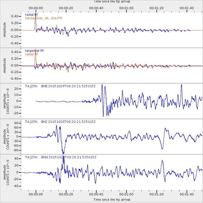
Signal To Noise
| Channel | StoN | STA | LTA |
| TA:J25K: :BHZ:20151026T09:20:21.525015Z | 4.340123 | 2.0694888E-6 | 4.768272E-7 |
| TA:J25K: :BHN:20151026T09:20:21.525015Z | 2.7630322 | 1.0551768E-6 | 3.8189089E-7 |
| TA:J25K: :BHE:20151026T09:20:21.525015Z | 1.6995648 | 6.8021E-7 | 4.00226E-7 |
| Arrivals |
| Ps | 7.7 SECOND |
| PpPs | 26 SECOND |
| PsPs/PpSs | 33 SECOND |


