You are here: Home > Network List > TA - USArray Transportable Network (new EarthScope stations) Stations List
> Station K27K Chicken, AK, USA > Earthquake Result Viewer
K27K Chicken, AK, USA - Earthquake Result Viewer
| Earthquake location: |
Hindu Kush Region, Afghanistan |
| Earthquake latitude/longitude: |
36.4/70.7 |
| Earthquake time(UTC): |
2015/10/26 (299) 09:09:32 GMT |
| Earthquake Depth: |
212 km |
| Earthquake Magnitude: |
7.5 MWW, 7.5 MWB |
| Earthquake Catalog/Contributor: |
NEIC PDE/NEIC COMCAT |
|
| Network: |
TA USArray Transportable Network (new EarthScope stations) |
| Station: |
K27K Chicken, AK, USA |
| Lat/Lon: |
64.03 N/142.08 W |
| Elevation: |
389 m |
|
| Distance: |
76.6 deg |
| Az: |
14.193 deg |
| Baz: |
333.318 deg |
| Ray Param: |
0.05036527 |
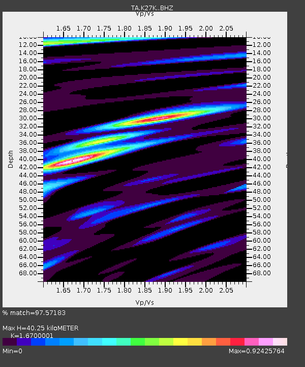
| Estimated Moho Depth: |
40.25 km |
| Estimated Crust Vp/Vs: |
1.67 |
| Assumed Crust Vp: |
6.566 km/s |
| Estimated Crust Vs: |
3.932 km/s |
| Estimated Crust Poisson's Ratio: |
0.22 |
|
| Radial Match: |
97.57183 % |
| Radial Bump: |
389 |
| Transverse Match: |
86.83768 % |
| Transverse Bump: |
400 |
| SOD ConfigId: |
7422571 |
| Insert Time: |
2019-04-21 05:01:00.831 +0000 |
| GWidth: |
2.5 |
| Max Bumps: |
400 |
| Tol: |
0.001 |
|

Signal To Noise
| Channel | StoN | STA | LTA |
| TA:K27K: :BHZ:20151026T09:20:28.225027Z | 4.6851068 | 2.506768E-6 | 5.3505033E-7 |
| TA:K27K: :BHN:20151026T09:20:28.225027Z | 3.6244783 | 1.1147353E-6 | 3.0755743E-7 |
| TA:K27K: :BHE:20151026T09:20:28.225027Z | 1.8246022 | 5.884534E-7 | 3.2251052E-7 |
| Arrivals |
| Ps | 4.2 SECOND |
| PpPs | 16 SECOND |
| PsPs/PpSs | 20 SECOND |


