You are here: Home > Network List > TA - USArray Transportable Network (new EarthScope stations) Stations List
> Station M27K Edge Creek, AK, USA > Earthquake Result Viewer
M27K Edge Creek, AK, USA - Earthquake Result Viewer
| Earthquake location: |
Hindu Kush Region, Afghanistan |
| Earthquake latitude/longitude: |
36.4/70.7 |
| Earthquake time(UTC): |
2015/10/26 (299) 09:09:32 GMT |
| Earthquake Depth: |
212 km |
| Earthquake Magnitude: |
7.5 MWW, 7.5 MWB |
| Earthquake Catalog/Contributor: |
NEIC PDE/NEIC COMCAT |
|
| Network: |
TA USArray Transportable Network (new EarthScope stations) |
| Station: |
M27K Edge Creek, AK, USA |
| Lat/Lon: |
62.36 N/141.88 W |
| Elevation: |
1536 m |
|
| Distance: |
78.1 deg |
| Az: |
14.878 deg |
| Baz: |
333.645 deg |
| Ray Param: |
0.04933074 |
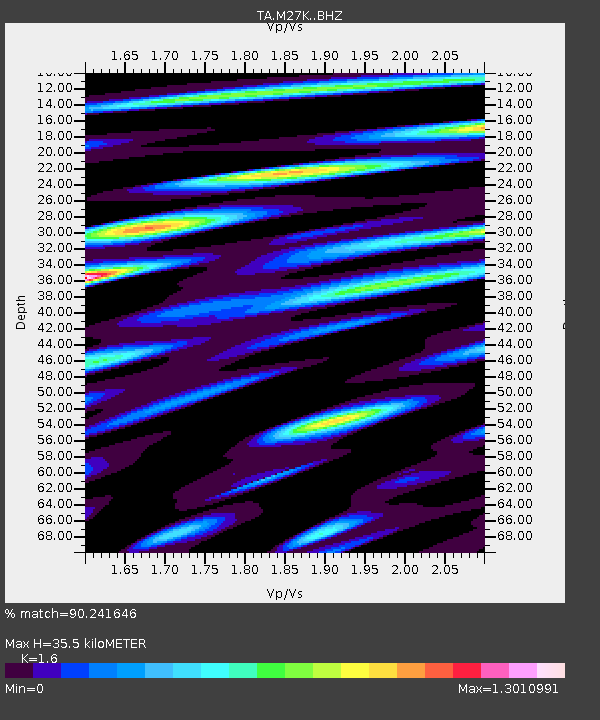
| Estimated Moho Depth: |
35.5 km |
| Estimated Crust Vp/Vs: |
1.60 |
| Assumed Crust Vp: |
6.566 km/s |
| Estimated Crust Vs: |
4.104 km/s |
| Estimated Crust Poisson's Ratio: |
0.18 |
|
| Radial Match: |
90.241646 % |
| Radial Bump: |
400 |
| Transverse Match: |
87.93296 % |
| Transverse Bump: |
400 |
| SOD ConfigId: |
7422571 |
| Insert Time: |
2019-04-21 05:01:08.135 +0000 |
| GWidth: |
2.5 |
| Max Bumps: |
400 |
| Tol: |
0.001 |
|

Signal To Noise
| Channel | StoN | STA | LTA |
| TA:M27K: :BHZ:20151026T09:20:36.74999Z | 5.432325 | 2.7754147E-6 | 5.1090734E-7 |
| TA:M27K: :BHN:20151026T09:20:36.74999Z | 3.3525007 | 1.4428493E-6 | 4.3038003E-7 |
| TA:M27K: :BHE:20151026T09:20:36.74999Z | 4.1233387 | 1.2203807E-6 | 2.9596907E-7 |
| Arrivals |
| Ps | 3.4 SECOND |
| PpPs | 14 SECOND |
| PsPs/PpSs | 17 SECOND |


