You are here: Home > Network List > TA - USArray Transportable Network (new EarthScope stations) Stations List
> Station O20K Slope Mountain, AK, USA > Earthquake Result Viewer
O20K Slope Mountain, AK, USA - Earthquake Result Viewer
| Earthquake location: |
Hindu Kush Region, Afghanistan |
| Earthquake latitude/longitude: |
36.4/70.7 |
| Earthquake time(UTC): |
2015/10/26 (299) 09:09:32 GMT |
| Earthquake Depth: |
212 km |
| Earthquake Magnitude: |
7.5 MWW, 7.5 MWB |
| Earthquake Catalog/Contributor: |
NEIC PDE/NEIC COMCAT |
|
| Network: |
TA USArray Transportable Network (new EarthScope stations) |
| Station: |
O20K Slope Mountain, AK, USA |
| Lat/Lon: |
60.08 N/152.62 W |
| Elevation: |
915 m |
|
| Distance: |
77.4 deg |
| Az: |
20.641 deg |
| Baz: |
325.455 deg |
| Ray Param: |
0.049780823 |
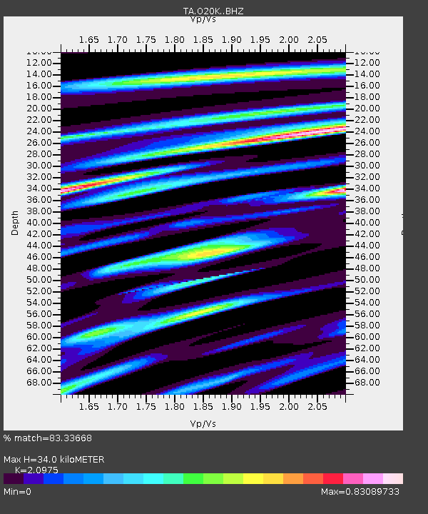
| Estimated Moho Depth: |
34.0 km |
| Estimated Crust Vp/Vs: |
2.10 |
| Assumed Crust Vp: |
6.566 km/s |
| Estimated Crust Vs: |
3.13 km/s |
| Estimated Crust Poisson's Ratio: |
0.35 |
|
| Radial Match: |
83.33668 % |
| Radial Bump: |
400 |
| Transverse Match: |
80.30456 % |
| Transverse Bump: |
400 |
| SOD ConfigId: |
7422571 |
| Insert Time: |
2019-04-21 05:01:13.958 +0000 |
| GWidth: |
2.5 |
| Max Bumps: |
400 |
| Tol: |
0.001 |
|

Signal To Noise
| Channel | StoN | STA | LTA |
| TA:O20K: :BHZ:20151026T09:20:33.075002Z | 2.0651836 | 2.74199E-6 | 1.3277221E-6 |
| TA:O20K: :BHN:20151026T09:20:33.075002Z | 1.0901405 | 1.6136568E-6 | 1.4802283E-6 |
| TA:O20K: :BHE:20151026T09:20:33.075002Z | 1.595553 | 1.938595E-6 | 1.2149987E-6 |
| Arrivals |
| Ps | 5.8 SECOND |
| PpPs | 16 SECOND |
| PsPs/PpSs | 21 SECOND |


