You are here: Home > Network List > TD - TransAlta Monitoring Network Stations List
> Station TD023 Z > Earthquake Result Viewer
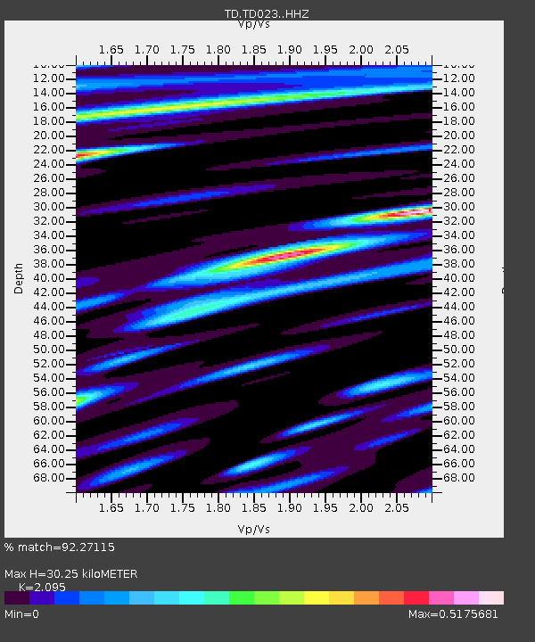
TD023 Z - Earthquake Result Viewer
| Earthquake location: |
Hindu Kush Region, Afghanistan |
| Earthquake latitude/longitude: |
36.4/70.7 |
| Earthquake time(UTC): |
2015/10/26 (299) 09:09:32 GMT |
| Earthquake Depth: |
212 km |
| Earthquake Magnitude: |
7.5 MWW, 7.5 MWB |
| Earthquake Catalog/Contributor: |
NEIC PDE/NEIC COMCAT |
|
| Network: |
TD TransAlta Monitoring Network |
| Station: |
TD023 Z |
| Lat/Lon: |
51.11 N/114.31 W |
| Elevation: |
1169 m |
|
| Distance: |
92.7 deg |
| Az: |
3.167 deg |
| Baz: |
355.948 deg |
| Ray Param: |
0.041275978 |
| Estimated Moho Depth: |
30.25 km |
| Estimated Crust Vp/Vs: |
2.10 |
| Assumed Crust Vp: |
6.178 km/s |
| Estimated Crust Vs: |
2.949 km/s |
| Estimated Crust Poisson's Ratio: |
0.35 |
|
| Radial Match: |
92.27115 % |
| Radial Bump: |
400 |
| Transverse Match: |
77.01594 % |
| Transverse Bump: |
400 |
| SOD ConfigId: |
7422571 |
| Insert Time: |
2019-04-21 05:01:21.891 +0000 |
| GWidth: |
2.5 |
| Max Bumps: |
400 |
| Tol: |
0.001 |
|

Signal To Noise
| Channel | StoN | STA | LTA |
| TD:TD023: :HHZ:20151026T09:21:48.979971Z | 3.4628668 | 1.5579639E-6 | 4.499058E-7 |
| TD:TD023: :HH1:20151026T09:21:48.979971Z | 0.7211646 | 4.29607E-7 | 5.9571283E-7 |
| TD:TD023: :HH2:20151026T09:21:48.979971Z | 1.1839876 | 8.8580225E-7 | 7.481516E-7 |
| Arrivals |
| Ps | 5.4 SECOND |
| PpPs | 15 SECOND |
| PsPs/PpSs | 20 SECOND |


