You are here: Home > Network List > US - United States National Seismic Network Stations List
> Station DGMT Dagmar, Montana, USA > Earthquake Result Viewer
DGMT Dagmar, Montana, USA - Earthquake Result Viewer

| Earthquake location: |
Hindu Kush Region, Afghanistan |
| Earthquake latitude/longitude: |
36.4/70.7 |
| Earthquake time(UTC): |
2015/10/26 (299) 09:09:32 GMT |
| Earthquake Depth: |
212 km |
| Earthquake Magnitude: |
7.5 MWW, 7.5 MWB |
| Earthquake Catalog/Contributor: |
NEIC PDE/NEIC COMCAT |
|
| Network: |
US United States National Seismic Network |
| Station: |
DGMT Dagmar, Montana, USA |
| Lat/Lon: |
48.47 N/104.20 W |
| Elevation: |
0.0 m |
|
| Distance: |
95.3 deg |
| Az: |
356.602 deg |
| Baz: |
4.119 deg |
| Ray Param: |
0.040637564 |
| Estimated Moho Depth: |
18.25 km |
| Estimated Crust Vp/Vs: |
1.88 |
| Assumed Crust Vp: |
6.438 km/s |
| Estimated Crust Vs: |
3.424 km/s |
| Estimated Crust Poisson's Ratio: |
0.30 |
|
| Radial Match: |
91.1866 % |
| Radial Bump: |
272 |
| Transverse Match: |
69.61362 % |
| Transverse Bump: |
400 |
| SOD ConfigId: |
7422571 |
| Insert Time: |
2019-04-21 05:01:34.618 +0000 |
| GWidth: |
2.5 |
| Max Bumps: |
400 |
| Tol: |
0.001 |
|
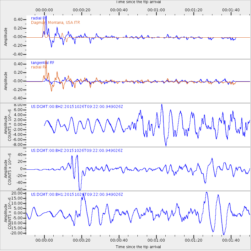
Signal To Noise
| Channel | StoN | STA | LTA |
| US:DGMT:00:BHZ:20151026T09:22:00.949026Z | 1.3952047 | 9.364428E-7 | 6.711867E-7 |
| US:DGMT:00:BH1:20151026T09:22:00.949026Z | 0.71178865 | 1.5154337E-6 | 2.1290502E-6 |
| US:DGMT:00:BH2:20151026T09:22:00.949026Z | 1.0044804 | 1.6574477E-6 | 1.6500549E-6 |
| Arrivals |
| Ps | 2.5 SECOND |
| PpPs | 8.0 SECOND |
| PsPs/PpSs | 11 SECOND |


