You are here: Home > Network List > UW - Pacific Northwest Regional Seismic Network Stations List
> Station LEBA Lebam, WA, USA > Earthquake Result Viewer
LEBA Lebam, WA, USA - Earthquake Result Viewer
| Earthquake location: |
Hindu Kush Region, Afghanistan |
| Earthquake latitude/longitude: |
36.4/70.7 |
| Earthquake time(UTC): |
2015/10/26 (299) 09:09:32 GMT |
| Earthquake Depth: |
212 km |
| Earthquake Magnitude: |
7.5 MWW, 7.5 MWB |
| Earthquake Catalog/Contributor: |
NEIC PDE/NEIC COMCAT |
|
| Network: |
UW Pacific Northwest Regional Seismic Network |
| Station: |
LEBA Lebam, WA, USA |
| Lat/Lon: |
46.55 N/123.56 W |
| Elevation: |
73 m |
|
| Distance: |
96.4 deg |
| Az: |
9.864 deg |
| Baz: |
348.455 deg |
| Ray Param: |
0.040336575 |
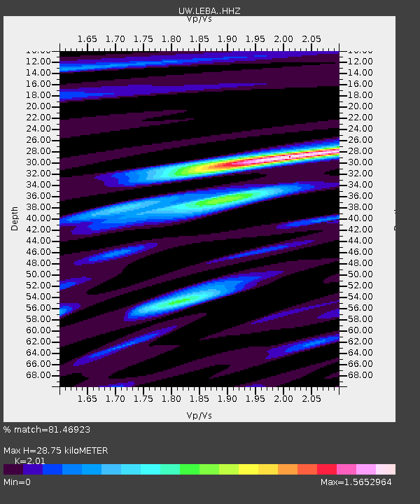
| Estimated Moho Depth: |
28.75 km |
| Estimated Crust Vp/Vs: |
2.01 |
| Assumed Crust Vp: |
6.566 km/s |
| Estimated Crust Vs: |
3.267 km/s |
| Estimated Crust Poisson's Ratio: |
0.34 |
|
| Radial Match: |
81.46923 % |
| Radial Bump: |
400 |
| Transverse Match: |
77.63814 % |
| Transverse Bump: |
400 |
| SOD ConfigId: |
7422571 |
| Insert Time: |
2019-04-21 05:01:41.192 +0000 |
| GWidth: |
2.5 |
| Max Bumps: |
400 |
| Tol: |
0.001 |
|

Signal To Noise
| Channel | StoN | STA | LTA |
| UW:LEBA: :HHZ:20151026T09:22:05.707998Z | 0.7668804 | 8.6880186E-7 | 1.1329039E-6 |
| UW:LEBA: :HHN:20151026T09:22:05.707998Z | 1.4739989 | 1.4259243E-6 | 9.67385E-7 |
| UW:LEBA: :HHE:20151026T09:22:05.707998Z | 2.3525133 | 1.9026871E-6 | 8.087891E-7 |
| Arrivals |
| Ps | 4.5 SECOND |
| PpPs | 13 SECOND |
| PsPs/PpSs | 17 SECOND |


