You are here: Home > Network List > UW - Pacific Northwest Regional Seismic Network Stations List
> Station WOLL Wollman Farm, Schrag, WA, USA > Earthquake Result Viewer
WOLL Wollman Farm, Schrag, WA, USA - Earthquake Result Viewer
| Earthquake location: |
Hindu Kush Region, Afghanistan |
| Earthquake latitude/longitude: |
36.4/70.7 |
| Earthquake time(UTC): |
2015/10/26 (299) 09:09:32 GMT |
| Earthquake Depth: |
212 km |
| Earthquake Magnitude: |
7.5 MWW, 7.5 MWB |
| Earthquake Catalog/Contributor: |
NEIC PDE/NEIC COMCAT |
|
| Network: |
UW Pacific Northwest Regional Seismic Network |
| Station: |
WOLL Wollman Farm, Schrag, WA, USA |
| Lat/Lon: |
47.06 N/118.92 W |
| Elevation: |
385 m |
|
| Distance: |
96.4 deg |
| Az: |
6.615 deg |
| Baz: |
352.192 deg |
| Ray Param: |
0.040326975 |
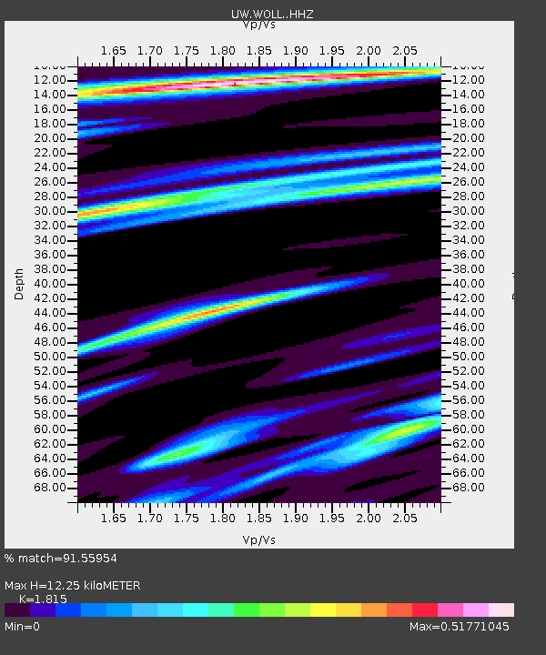
| Estimated Moho Depth: |
12.25 km |
| Estimated Crust Vp/Vs: |
1.82 |
| Assumed Crust Vp: |
6.419 km/s |
| Estimated Crust Vs: |
3.537 km/s |
| Estimated Crust Poisson's Ratio: |
0.28 |
|
| Radial Match: |
91.55954 % |
| Radial Bump: |
315 |
| Transverse Match: |
79.18755 % |
| Transverse Bump: |
389 |
| SOD ConfigId: |
7422571 |
| Insert Time: |
2019-04-21 05:01:46.995 +0000 |
| GWidth: |
2.5 |
| Max Bumps: |
400 |
| Tol: |
0.001 |
|

Signal To Noise
| Channel | StoN | STA | LTA |
| UW:WOLL: :HHZ:20151026T09:22:05.848013Z | 1.6814523 | 9.1723246E-7 | 5.4550014E-7 |
| UW:WOLL: :HHN:20151026T09:22:05.848013Z | 0.80913204 | 2.479503E-7 | 3.064399E-7 |
| UW:WOLL: :HHE:20151026T09:22:05.848013Z | 1.1069682 | 3.748406E-7 | 3.3861915E-7 |
| Arrivals |
| Ps | 1.6 SECOND |
| PpPs | 5.3 SECOND |
| PsPs/PpSs | 6.9 SECOND |


