You are here: Home > Network List > XD14 - Illuminating the architecture of the greater Mount St. Helens magmatic systems f Stations List
> Station MH09 "Mount St Helens, WA" > Earthquake Result Viewer
MH09 "Mount St Helens, WA" - Earthquake Result Viewer
| Earthquake location: |
Hindu Kush Region, Afghanistan |
| Earthquake latitude/longitude: |
36.4/70.7 |
| Earthquake time(UTC): |
2015/10/26 (299) 09:09:32 GMT |
| Earthquake Depth: |
212 km |
| Earthquake Magnitude: |
7.5 MWW, 7.5 MWB |
| Earthquake Catalog/Contributor: |
NEIC PDE/NEIC COMCAT |
|
| Network: |
XD Illuminating the architecture of the greater Mount St. Helens magmatic systems f |
| Station: |
MH09 "Mount St Helens, WA" |
| Lat/Lon: |
46.30 N/121.80 W |
| Elevation: |
989 m |
|
| Distance: |
96.9 deg |
| Az: |
8.706 deg |
| Baz: |
349.861 deg |
| Ray Param: |
0.040194623 |
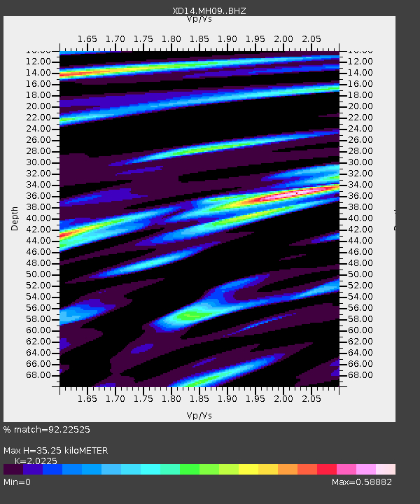
| Estimated Moho Depth: |
35.25 km |
| Estimated Crust Vp/Vs: |
2.02 |
| Assumed Crust Vp: |
6.597 km/s |
| Estimated Crust Vs: |
3.262 km/s |
| Estimated Crust Poisson's Ratio: |
0.34 |
|
| Radial Match: |
92.22525 % |
| Radial Bump: |
400 |
| Transverse Match: |
77.11301 % |
| Transverse Bump: |
400 |
| SOD ConfigId: |
7422571 |
| Insert Time: |
2019-04-21 05:02:03.507 +0000 |
| GWidth: |
2.5 |
| Max Bumps: |
400 |
| Tol: |
0.001 |
|

Signal To Noise
| Channel | StoN | STA | LTA |
| XD:MH09: :BHZ:20151026T09:22:07.825002Z | 2.1139808 | 1.0759588E-6 | 5.089729E-7 |
| XD:MH09: :BHN:20151026T09:22:07.825002Z | 1.3339422 | 4.1703117E-7 | 3.1263062E-7 |
| XD:MH09: :BHE:20151026T09:22:07.825002Z | 0.589965 | 2.7495864E-7 | 4.6605928E-7 |
| Arrivals |
| Ps | 5.6 SECOND |
| PpPs | 16 SECOND |
| PsPs/PpSs | 21 SECOND |


