You are here: Home > Network List > IC - New China Digital Seismograph Network Stations List
> Station BJT Baijiatuan, Beijing, China > Earthquake Result Viewer
BJT Baijiatuan, Beijing, China - Earthquake Result Viewer
| Earthquake location: |
Tonga Islands |
| Earthquake latitude/longitude: |
-21.9/-173.8 |
| Earthquake time(UTC): |
2008/10/19 (293) 05:10:33 GMT |
| Earthquake Depth: |
29 km |
| Earthquake Magnitude: |
6.8 MB, 7.0 MS, 6.9 MW, 6.9 MW |
| Earthquake Catalog/Contributor: |
WHDF/NEIC |
|
| Network: |
IC New China Digital Seismograph Network |
| Station: |
BJT Baijiatuan, Beijing, China |
| Lat/Lon: |
40.02 N/116.17 E |
| Elevation: |
197 m |
|
| Distance: |
89.6 deg |
| Az: |
313.803 deg |
| Baz: |
119.19 deg |
| Ray Param: |
0.041728757 |
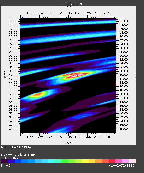
| Estimated Moho Depth: |
40.0 km |
| Estimated Crust Vp/Vs: |
1.89 |
| Assumed Crust Vp: |
6.464 km/s |
| Estimated Crust Vs: |
3.411 km/s |
| Estimated Crust Poisson's Ratio: |
0.31 |
|
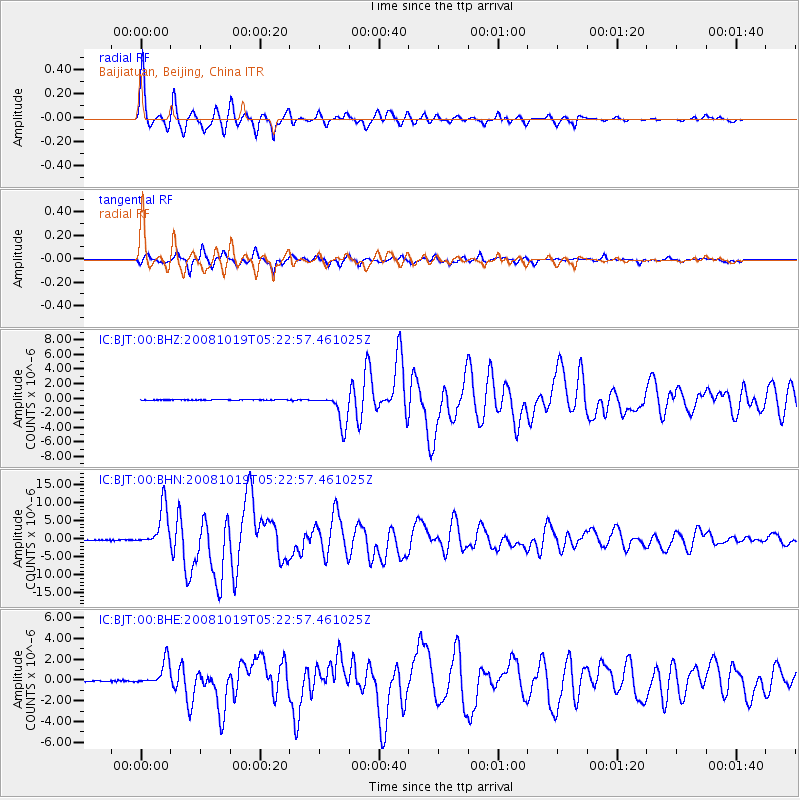
| Radial Match: |
97.96539 % |
| Radial Bump: |
330 |
| Transverse Match: |
95.30845 % |
| Transverse Bump: |
356 |
| SOD ConfigId: |
2556 |
| Insert Time: |
2010-03-04 21:20:31.005 +0000 |
| GWidth: |
2.5 |
| Max Bumps: |
400 |
| Tol: |
0.001 |
|
Signal To Noise
| Channel | StoN | STA | LTA |
| IC:BJT:00:BHN:20081019T05:22:57.461025Z | 68.26573 | 5.5807104E-6 | 8.174981E-8 |
| IC:BJT:00:BHE:20081019T05:22:57.461025Z | 33.279934 | 1.2144986E-6 | 3.6493418E-8 |
| IC:BJT:00:BHZ:20081019T05:22:57.461025Z | 54.446285 | 2.2018544E-6 | 4.0440852E-8 |
| Arrivals |
| Ps | 5.6 SECOND |
| PpPs | 18 SECOND |
| PsPs/PpSs | 23 SECOND |


