You are here: Home > Network List > IU - Global Seismograph Network (GSN - IRIS/USGS) Stations List
> Station MA2 Magadan, Russia > Earthquake Result Viewer
MA2 Magadan, Russia - Earthquake Result Viewer
| Earthquake location: |
Bonin Islands, Japan Region |
| Earthquake latitude/longitude: |
27.8/140.5 |
| Earthquake time(UTC): |
2015/05/30 (150) 11:23:02 GMT |
| Earthquake Depth: |
678 km |
| Earthquake Magnitude: |
7.8 MWP, 8.5 MI |
| Earthquake Catalog/Contributor: |
NEIC PDE/NEIC COMCAT |
|
| Network: |
IU Global Seismograph Network (GSN - IRIS/USGS) |
| Station: |
MA2 Magadan, Russia |
| Lat/Lon: |
59.58 N/150.77 E |
| Elevation: |
339 m |
|
| Distance: |
32.5 deg |
| Az: |
9.725 deg |
| Baz: |
197.094 deg |
| Ray Param: |
0.0750132 |
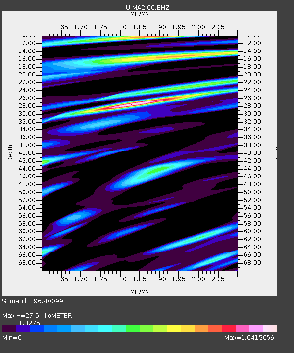
| Estimated Moho Depth: |
27.5 km |
| Estimated Crust Vp/Vs: |
1.83 |
| Assumed Crust Vp: |
6.134 km/s |
| Estimated Crust Vs: |
3.356 km/s |
| Estimated Crust Poisson's Ratio: |
0.29 |
|
| Radial Match: |
96.40099 % |
| Radial Bump: |
399 |
| Transverse Match: |
87.47371 % |
| Transverse Bump: |
400 |
| SOD ConfigId: |
976571 |
| Insert Time: |
2015-06-13 11:29:20.277 +0000 |
| GWidth: |
2.5 |
| Max Bumps: |
400 |
| Tol: |
0.001 |
|

Signal To Noise
| Channel | StoN | STA | LTA |
| IU:MA2:00:BHZ:20150530T11:28:11.569001Z | 94.87115 | 1.8959882E-4 | 1.9984877E-6 |
| IU:MA2:00:BH1:20150530T11:28:11.569001Z | 71.70253 | 9.750921E-5 | 1.3599132E-6 |
| IU:MA2:00:BH2:20150530T11:28:11.569001Z | 79.915985 | 3.2882763E-5 | 4.1146666E-7 |
| Arrivals |
| Ps | 3.9 SECOND |
| PpPs | 12 SECOND |
| PsPs/PpSs | 16 SECOND |


